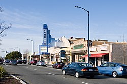
El Cerrito, California
| El Cerrito | ||
|---|---|---|
| City | ||
| City of El Cerrito | ||

San Pablo Avenue, with the historic Cerrito Theater
|
||
|
||
 Location in Contra Costa County and the state of California |
||
| Location in the United States | ||
| Coordinates: 37°54′57″N 122°18′42″W / 37.91583°N 122.31167°WCoordinates: 37°54′57″N 122°18′42″W / 37.91583°N 122.31167°W | ||
| Country |
|
|
| State |
|
|
| County | Contra Costa | |
| Incorporated | August 23, 1917 | |
| Government | ||
| • Mayor | Greg Lyman | |
| • State Senator | Nancy Skinner (D) | |
| • State Assembly | Tony Thurmond (D) | |
| • U. S. Congress | Mark DeSaulnier (D) | |
| • County Board | District 1: John Gioia |
|
| Area | ||
| • Total | 3.688 sq mi (9.551 km2) | |
| • Land | 3.688 sq mi (9.551 km2) | |
| • Water | 0 sq mi (0 km2) 0% | |
| Elevation | 69 ft (21 m) | |
| Population (2010) | ||
| • Total | 23,549 | |
| • Density | 6,400/sq mi (2,500/km2) | |
| Time zone | PST (UTC-8) | |
| • Summer (DST) | PDT (UTC-7) | |
| ZIP code | 94530 | |
| Area code(s) | 510 | |
| GNIS feature IDs | 277504, 2410410 | |
| Website | www |
|
El Cerrito is a city in Contra Costa County, California, United States, and forms part of the San Francisco Bay Area. It has a population of 23,549 according to the 2010 census. El Cerrito was founded by refugees from the 1906 San Francisco earthquake. It was incorporated in 1917 as a village with 1500 residents. As of the census in 2000, there were 23,171 people, 10,208 households and 5971 families in the city. The top 20 employers in the city, according to the 2013 Comprehensive Annual Financial Report, include such entities as the West Contra Costa Unified School District, City of El Cerrito, Lucky Stores, Pastime ACE Hardware, and Honda of El Cerrito.
El Cerrito was founded by refugees from the 1906 San Francisco earthquake. They settled in what was then Don Víctor Castro's Rancho San Pablo, and adjacent to the ranch owned by the family of Luís María Peralta, the Rancho San Antonio. A post office opened at the settlement in 1909 and the refugee camp became known as Rust, after Wilhelm F. Rust, its first postmaster. The village's residents did not care for the name and changed it to El Cerrito in 1916. A year later, El Cerrito was incorporated as a village with 1,500 residents. The name means "little hill" or knoll.
According to the United States Census Bureau, the city has a total area of 3.7 square miles (9.6 km2), all of it land. The city is at an elevation of 69 feet (21 m).
El Cerrito is located on the eastern shore of San Francisco Bay. The hilly areas of El Cerrito provide spectacular views of its famous neighbor and the Golden Gate Bridge. El Cerrito is located along Interstate 80, and nearby Interstate 580. The city is less than 30 miles from two major airports. El Cerrito is bordered by Albany and Kensington to the south, the Richmond annex to the west, East Richmond Heights to the north, and Wildcat Canyon Regional Park to the east. Local landmark Albany Hill is in Albany, just across the border with El Cerrito. (El Cerrito—Spanish, "the little hill"—takes its name from Albany Hill.) The Hayward Fault runs through El Cerrito. In addition, El Cerrito is within 150 meters (490 feet) of Berkeley to the southeast.
...
Wikipedia


