Egerton, Cheshire
| Egerton | |
|---|---|
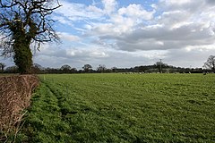
 Sheep pasture in the north of the civil parish |
|
| Egerton shown within Cheshire | |
| Population | 81 (2001) |
| OS grid reference | SJ522520 |
| Civil parish |
|
| Unitary authority | |
| Ceremonial county | |
| Region | |
| Country | England |
| Sovereign state | United Kingdom |
| Post town | MALPAS |
| Postcode district | SY14 |
| Dialling code | 01829 |
| Police | Cheshire |
| Fire | Cheshire |
| Ambulance | North West |
| EU Parliament | North West England |
| UK Parliament | |
Egerton is a civil parish in the unitary authority of Cheshire East and the ceremonial county of Cheshire, England. A largely rural area, the parish includes the small settlement of Egerton Green (at SJ522520), which lies 3¾ miles to the north east of Malpas and 8 miles to the west of Nantwich, as well as Fairy Glen. The population is less than 100. Nearby villages include Bickerton, Bulkeley and No Man's Heath.
In the Middle Ages, an ancestor of the Sir Roland Egerton, 1st Baronet, William le Belward, took the surname of Egerton from the lordship of Egerton, Cheshire, which he inherited. His descendants, the Egerton family, include the dukes of Bridgewater and Sutherland.
Egerton is administered jointly with Bickerton by the Bickerton & Egerton Parish Council. From 1974 the civil parish was served by Crewe and Nantwich Borough Council, which was succeeded on 1 April 2009 by the unitary authority of Cheshire East. Egerton falls in the parliamentary constituency of Eddisbury, which has been represented by Antoinette Sandbach since 2015, after being represented by Stephen O'Brien (1999–2015).
...
Wikipedia

