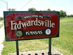
Edwardsville, Kansas
| Edwardsville, Kansas | |
|---|---|
| City | |

Entrance sign in Edwardsville
|
|
 Location within Wyandotte County and Kansas |
|
| Coordinates: 39°3′48″N 94°48′52″W / 39.06333°N 94.81444°WCoordinates: 39°3′48″N 94°48′52″W / 39.06333°N 94.81444°W | |
| Country | United States |
| State | Kansas |
| County | Wyandotte |
| Area | |
| • Total | 9.36 sq mi (24.24 km2) |
| • Land | 9.04 sq mi (23.41 km2) |
| • Water | 0.32 sq mi (0.83 km2) |
| Elevation | 781 ft (238 m) |
| Population (2010) | |
| • Total | 4,340 |
| • Estimate (2013) | 4,355 |
| • Density | 460/sq mi (180/km2) |
| Time zone | Central (CST) (UTC-6) |
| • Summer (DST) | CDT (UTC-5) |
| ZIP codes | 66111, 66113 |
| Area code | 913 |
| FIPS code | 20-20000 |
| GNIS feature ID | 0478886 |
| Website | edwardsvilleks.org |
Edwardsville is a city in Wyandotte County, Kansas, United States and is part of the "Unified Government" which also contains Kansas City, Kansas, most of Bonner Springs, and roughly one quarter of Lake Quivira. It is part of the Kansas City Metropolitan Area. As of the 2010 census, the city population was 4,340.
Edwardsville was surveyed in 1869 on land formerly belonging to Half Moon, an Indian chief of the Delawares. It was named for John H. Edwards, a general passenger agent for the Union Pacific Railroad, who later served as a justice of the peace and state senator from Ellis County, Kansas.
Edwardsville is located at 39°03′48″N 94°48′52″W / 39.063428°N 94.814347°W (39.063428, -94.814347). According to the United States Census Bureau, the city has a total area of 9.36 square miles (24.24 km2), of which, 9.04 square miles (23.41 km2) is land and 0.32 square miles (0.83 km2) is water.
As of the census of 2010, there were 4,340 people, 1,632 households, and 1,107 families residing in the city. The population density was 480.1 inhabitants per square mile (185.4/km2). There were 1,716 housing units at an average density of 189.8 per square mile (73.3/km2). The racial makeup of the city was 86.6% White, 6.0% African American, 0.8% Native American, 0.8% Asian, 0.1% Pacific Islander, 2.8% from other races, and 2.9% from two or more races. Hispanic or Latino of any race were 7.3% of the population.
...
Wikipedia
