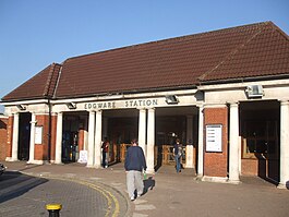
Edgware tube station
| Edgware |
|
|---|---|
 |
|
|
Location of Edgware in Greater London
|
|
| Location | Edgware |
| Local authority | London Borough of Barnet |
| Managed by | London Underground |
| Number of platforms | 3 |
| Accessible | Yes |
| Fare zone | 5 |
| London Underground annual entry and exit | |
| 2012 |
|
| 2013 |
|
| 2014 |
|
| 2015 |
|
| Key dates | |
| 1924 | Opened (CCE&HR) |
| 1 June 1964 | Goods yard closed |
| Other information | |
| Lists of stations | |
| WGS84 | 51°36′50″N 0°16′30″W / 51.614°N 0.275°WCoordinates: 51°36′50″N 0°16′30″W / 51.614°N 0.275°W |
|
|
|
Edgware is a London Underground station in Edgware, in the London Borough of Barnet, in North London. The station is the terminus of the Edgware branch of the Northern line and the next station towards central London is Burnt Oak. Edgware is in Travelcard Zone 5.
The station is in Station Road, Edgware (part of the A5100). This road runs north-east from the High Street (A5), and the station is about 500 metres from the A5 on the right (south-east) side. The building is set back from the road, and there is a circular service road between the building and the road to allow cars to pull in and pick up or set down.
Just to the right of the station, viewed from Station Road, is a road to the bus station and bus garage.
The station was opened on 18 August 1924 as the terminus of the second phase of the Underground Group's extension of the Charing Cross, Euston & Hampstead Railway from Golders Green. It was designed by architect Stanley Heaps. There are three platforms, an island lying east of a single platform (platform 1). A trainshed covers the island platforms (2 and 3).
Despite having already had a railway station since 1867 (Edgware station on the London and North Eastern Railway), Edgware was, in 1924, still very much a village in character. The new Underground station was built on the north edge of the village in open fields and, as intended, the new line stimulated rapid suburban expansion along its length. By the end of the decade, what had formerly been fields was quickly being covered with new housing.
...
Wikipedia

