Edam-Volendam
| Edam-Volendam | |||
|---|---|---|---|
| Municipality | |||

Aerial view of Edam-Volendam
|
|||
|
|||
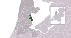
 Location in North Holland |
|||
| Coordinates: 52°30′N 5°3′E / 52.500°N 5.050°ECoordinates: 52°30′N 5°3′E / 52.500°N 5.050°E | |||
| Country | Netherlands | ||
| Province | North Holland | ||
| Government | |||
| • Body | Municipal council | ||
| • Mayor | Willem van Beek (CDA) | ||
| Area | |||
| • Total | 24.78 km2 (9.57 sq mi) | ||
| • Land | 16.31 km2 (6.30 sq mi) | ||
| • Water | 8.47 km2 (3.27 sq mi) | ||
| Elevation | −1 m (−3 ft) | ||
| Population (May 2014) | |||
| • Total | 28,925 | ||
| • Density | 1,773/km2 (4,590/sq mi) | ||
| Time zone | CET (UTC+1) | ||
| • Summer (DST) | CEST (UTC+2) | ||
| Postcode | 1130–1135, 1470–1477 | ||
| Area code | 0299 | ||
| Website | www |
||
Edam-Volendam (![]() pronunciation ) is a municipality in the northwest Netherlands, in the province of North Holland, consisting of the towns of Edam and Volendam, whose centres lie just 3 km apart. Since 2016, the former municipality of Zeevang has been part of Edam-Volendam.
pronunciation ) is a municipality in the northwest Netherlands, in the province of North Holland, consisting of the towns of Edam and Volendam, whose centres lie just 3 km apart. Since 2016, the former municipality of Zeevang has been part of Edam-Volendam.
Edam-Volendam has about 35,000 inhabitants and covers an area of about 80 km².
The municipal council of Edam-Volendam consists of 25 seats, which are divided as follows (2016):
...
Wikipedia


