Economy of Ascension Island
|
Ascension Island |
|||||
|---|---|---|---|---|---|
|
|||||
|
Anthem: "God Save the Queen"
|
|||||
 |
|||||
| Capital and largest settlement |
Georgetown 7°56′S 14°25′W / 7.933°S 14.417°W |
||||
| Official languages | English | ||||
| Part of | Saint Helena, Ascension and Tristan da Cunha | ||||
| Government | appointed Administrator | ||||
|
• Queen
|
Elizabeth II | ||||
|
• Governor
|
Lisa Phillips | ||||
| Marc Holland | |||||
| Establishment | |||||
|
• First inhabited
|
1815 | ||||
|
• Dependency of St Helena
|
12 September 1922 | ||||
| 1 September 2009 | |||||
| Area | |||||
|
• Total
|
88 km2 (34 sq mi) (219th) | ||||
|
• Water (%)
|
0 | ||||
| Population | |||||
|
• February 2016 census
|
806 | ||||
| Currency |
Saint Helena pound (US$ accepted) (SHP) |
||||
| Time zone | GMT (UTC) | ||||
| Drives on the | left | ||||
| Calling code | +247 | ||||
| ISO 3166 code | SH-AC | ||||
| Internet TLD |
.ac UK Postcode: ASCN 1ZZ |
||||
Coordinates: 7°56′S 14°22′W / 7.933°S 14.367°W
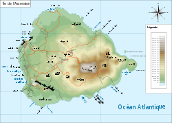
Ascension Island is an isolated volcanic island in the equatorial waters of the South Atlantic Ocean, around 1,600 kilometres (1,000 mi) from the coast of Africa and 2,250 kilometres (1,400 mi) from the coast of Brazil, which is roughly midway between the horn of South America and Africa. It is governed as part of the British Overseas Territory of Saint Helena, Ascension and Tristan da Cunha, of which the main island, Saint Helena, is around 1,300 kilometres (800 mi) to the southeast. The territory also includes the sparsely populated Tristan da Cunha archipelago, some 3,730 kilometres (2,300 mi) to the south, about halfway to the Antarctic Circle.
The island is named after the day of its recorded discovery, Ascension Day. It played a role as an important safe haven and coaling station to mariners and for commercial airliners during the days of international air travel by flying boats. During World War II it was an important naval and air station, especially providing antisubmarine warfare bases in the Battle of the Atlantic. Ascension Island was garrisoned by the British Admiralty from 22 October 1815 to 1922.
...
Wikipedia


