Echt-Susteren
|
Echt-Susteren Ech-Zöstere |
|||
|---|---|---|---|
| Municipality | |||

Church in Nieuwstadt
|
|||
|
|||
 Location in Limburg |
|||
| Coordinates: 51°6′N 5°52′E / 51.100°N 5.867°ECoordinates: 51°6′N 5°52′E / 51.100°N 5.867°E | |||
| Country | Netherlands | ||
| Province | Limburg | ||
| Established | 1 January 2003 | ||
| Government | |||
| • Body | Municipal council | ||
| • Mayor | Jos Hessels (CDA) | ||
| Area | |||
| • Total | 104.53 km2 (40.36 sq mi) | ||
| • Land | 103.11 km2 (39.81 sq mi) | ||
| • Water | 1.42 km2 (0.55 sq mi) | ||
| Elevation | 30 m (100 ft) | ||
| Population (May 2014) | |||
| • Total | 31,975 | ||
| • Density | 310/km2 (800/sq mi) | ||
| Time zone | CET (UTC+1) | ||
| • Summer (DST) | CEST (UTC+2) | ||
| Postcode | 6100–6118 | ||
| Area code | 046, 0475 | ||
| Website | www |
||
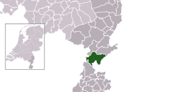
Echt-Susteren (Dutch ![]() pronunciation ; Limburgish: Ech-Zöstere) is a municipality in the southeastern Netherlands. Echt-Susteren was created in 2003 by merging the former municipalities of Echt and Susteren.
pronunciation ; Limburgish: Ech-Zöstere) is a municipality in the southeastern Netherlands. Echt-Susteren was created in 2003 by merging the former municipalities of Echt and Susteren.
Susteren is situated in a Euregional area. In the west the municipality borders to Belgium and in the east to Germany. The narrowest is only 4.8 km wide. It is possible to walk from Germany to Belgium via Netherlands in under an hour. The area of Echt-Susteren is a green municipality also known as the green waist of Limburg.
Aasterberg, Baakhoven, Berkelaar, Dieteren, Echt, Echterbosch, Gebroek, Heide, Hingen, Illikhoven, Kokkelert, Koningsbosch, Maria-Hoop, Nieuwstadt, Oevereind, Ophoven, Oud-Roosteren, Peij, Pepinusbrug, Roosteren, Schilberg, Sint Joost, Slek, Susteren, Visserweert.
...
Wikipedia


