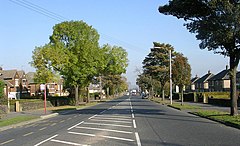
Eccleshill, West Yorkshire
| Eccleshill | |
|---|---|
 Harrogate Road, Eccleshill |
|
| Eccleshill shown within West Yorkshire | |
| Population | 17,945 (Ward. 2011) |
| OS grid reference | SE175358 |
| Metropolitan borough | |
| Metropolitan county | |
| Region | |
| Country | England |
| Sovereign state | United Kingdom |
| Post town | BRADFORD |
| Postcode district | BD2 & BD10 |
| Dialling code | 01274 |
| Police | West Yorkshire |
| Fire | West Yorkshire |
| Ambulance | Yorkshire |
| EU Parliament | Yorkshire and the Humber |
| Councillors |
|
Eccleshill is an area, former village, and ward in the City of Bradford Metropolitan District in the county of West Yorkshire, England. The ward population of Eccleshill is 17,540, increasing at the 2011 Census to 17,945.
Eccleshill is a more or less completely residential urban area with very little open space although there is substantial open land directly to the east.
The origins of the name Eccleshill are uncertain. At the time of the Domesday Book the area was known as Egleshill either meaning 'eagles hill' or perhaps named after a Saxon landlord called Aikel or Eckil—alternatively it could mean Ecclesiastical Hill.
In Roman times the Eccleshill area was crossed by two lanes. One lane was along what is now Norman Lane and the other to Apperley Bridge down the road now known as Bank.
After the Norman Conquest the lands of Eccleshill were given to William, Earl of Warren. In 1274 ownership of lands passed to the Sheffields and in 1407 to the Bolling family of Calverley then the Scargills, Saviles, Wyatts, Zouches, Stanhopes, Hirds, and then to Jeremiah Rawson.
In the Middle Ages Eccleshill was shunned by church authorities after a supposed incident in which it is said a preacher or monk was stoned to death on the main road though Eccleshill village. This supposed incident is said to be the reason behind naming the main road 'Stony Lane'. The real explanation may be that either the road was stony or that it led on to Stone Hall.
In 1713 Eccleshill Hall was built for Dr Stanhope, located to the east of Stony Lane at the site of previous Eccleshill Halls, on what is now Victoria Road. Eccleshill hall was demolished in 1878 and all that remains are parts of stone gateposts embedded in a roadside wall.
Initially the churches built in Eccleshill were nonconformist. Before 1775 the only place of worship in Eccleshill was The Quaker Meeting House on Tunwell Lane. In 1775 Prospect Chapel also known as Bank Top Chapel a Wesleyan Chapel was constructed on Lands Lane off Norman Lane. In 1776 Methodist John Wesley (1703-1791) preached there. On the opposite side of Norman Lane is Prospect Chapel burial ground, created in 1823. Doctrinal disagreement led to a split and the establishment in 1823 of Salem Independent Chapel. Salem Chapel and Sunday school both now demolished, were built on Dobby Row, an event that was to prompt the renaming of the street to Chapel Street. The Chapel Street chapel was eventually replaced by the Congregational Church on Victoria Road near Harrogate Road, built in 1889. Salem Chapel burial ground remains on Chapel Street. The Congregational Church was demolished in the 1960s and the United Reformed Church, a single storey building built on the site in 1967 and the Congregational Church building was demolished in 1979/80.
...
Wikipedia

