East Whiteland Township
| East Whiteland Township | |
| Township | |
| Country | United States |
|---|---|
| State | Pennsylvania |
| County | Chester |
| Elevation | 427 ft (130.1 m) |
| Coordinates | 40°02′20″N 75°33′18″W / 40.03889°N 75.55500°WCoordinates: 40°02′20″N 75°33′18″W / 40.03889°N 75.55500°W |
| Area | 11.0 sq mi (28.5 km2) |
| - land | 11.0 sq mi (28 km2) |
| - water | 0.0 sq mi (0 km2), 0% |
| Population | 10,650 (2010) |
| Density | 968.2/sq mi (373.8/km2) |
| Founded | 1704 |
| Township Manager | Richard Orlow |
| Timezone | EST (UTC-5) |
| - summer (DST) | EDT (UTC-4) |
| Area code | 610 |
|
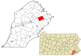
Location in Chester County and the state of Pennsylvania.
|
|
|
Location of Pennsylvania in the United States
|
|
|
Website: www |
|
East Whiteland Township is a township in Chester County, Pennsylvania, United States. The population was 10,650 at the 2010 census. Mailing addresses associated with East Whiteland include Malvern, Frazer, and a small area of Exton.
Founded in 1704, Whiteland Township was made up of what is today known as East and West Whiteland townships. The first European settlers were Welsh. The name Whiteland came from Whitford Garden in Flintshire, Wales. Whiteland Township was divided into two townships in 1765.
Native Americans called the area "The Dark Valley" because of the numerous trees and undergrowth. During the American Revolution, Gen. George Washington and many of his troops camped at Malin Hall here. They were preparing for a September 16, 1777, encounter with British General William Howe. The Continental Army also camped near White Horse Inn on Swedesford Road. Because of bad weather, however, the "Battle of the Clouds" was never fought.
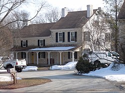
The Lapp Log House, St. Peter's Church in the Great Valley, Spring Mill Complex, and White Horse Tavern are listed on the National Register of Historic Places.
According to the United States Census Bureau, the township has a total area of 11.0 square miles (28 km2), of which 0.04 square miles (0.10 km2), or 0.27%, is water. East Whiteland Township is located about 25 miles (40 km) west of Philadelphia.
...
Wikipedia


