East Uniontown, Pennsylvania
| East Uniontown, Pennsylvania | |
| Census-designated place | |
| Country | United States |
|---|---|
| State | Pennsylvania |
| County | Fayette |
| Townships | North Union, South Union |
| Coordinates | 39°53′51″N 79°42′16″W / 39.89750°N 79.70444°WCoordinates: 39°53′51″N 79°42′16″W / 39.89750°N 79.70444°W |
| Area | 2.0 sq mi (5 km2) |
| - land | 2.0 sq mi (5 km2) |
| - water | 0.0 sq mi (0 km2) |
| Population | 2,419 (2010) |
| Density | 1,210.1/sq mi (467/km2) |
| Timezone | EST (UTC-4) |
| - summer (DST) | EDT (UTC-5) |
| Area code | 724 |
|
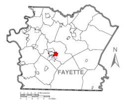
Location of East Uniontown in Fayette County
|
|
|
Location of Fayette County in Pennsylvania
|
|
|
Location of Pennsylvania in the United States
|
|
East Uniontown is a census-designated place (CDP) in Fayette County, Pennsylvania, United States. The population was 2,419 at the 2010 census, down from 2,760 at the 2000 census.
East Uniontown is located primarily in North Union Township at 39°53′51″N 79°42′16″W / 39.89750°N 79.70444°W (39.897604, -79.704464). The CDP extends west into South Union Township as well. It is bordered to the northwest by the city of Uniontown, the Fayette County seat. To the north it is bordered by the Oliver CDP, and to the south by the Hopwood CDP. To the east is Lemont Furnace.
U.S. Route 40 Business (the National Pike) passes through the western part of East Uniontown, forming the boundary between North Union and South Union townships. The two-lane road leads northwest into the center of Uniontown and southeast to U.S. Route 40 in Hopwood.
According to the United States Census Bureau, the East Uniontown CDP has a total area of 2.0 square miles (5.2 km2), all of it land.
...
Wikipedia


