East Pennsboro Township, Cumberland County, Pennsylvania
| East Pennsboro Township, Pennsylvania | |
|---|---|
| Township | |

West Fairview is a former borough that is now part of the township.
|
|
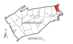
 Map of Cumberland County, Pennsylvania highlighting East Pennsboro Township |
|
 Map of Cumberland County, Pennsylvania |
|
| Country | United States |
| State | Pennsylvania |
| County | Cumberland |
| Government | |
| • Type | Board of Commissioners |
| • President | Scott Dardick |
| • Vice President | Amy Elizabeth Gish |
| • Commissioner | Wayne Melnick |
| • Commissioner | John Kuntzelman |
| • Commissioner | George Tyson |
| Area | |
| • Total | 10.7 sq mi (27.7 km2) |
| • Land | 10.4 sq mi (26.9 km2) |
| • Water | 0.3 sq mi (0.8 km2) |
| Population (2010) | |
| • Total | 20,228 |
| • Density | 1,947/sq mi (751.6/km2) |
| Time zone | Eastern (EST) (UTC-5) |
| • Summer (DST) | EDT (UTC-4) |
| Area code(s) | 717 |
| Website | www |
East Pennsboro Township is a township in Cumberland County, Pennsylvania, United States. The population was 20,228 at the 2010 census, up from 18,254 at the 2000 census. East Pennsboro is the second most populous municipality in Cumberland County. The township is located along the western banks of the Susquehanna River, across from Harrisburg. There are many large corporations based in East Pennsboro Township that use the Camp Hill postal address, including the Rite Aid Corporation and Gannett Fleming.
The township is in the northeast corner of Cumberland County, bordered to the east by the Susquehanna River, which separates it from Dauphin County. The township's natural northern boundary is the crest of Blue Mountain, which separates it from Perry County. U.S. Route 11/15 parallels the Susquehanna as the main north-to-south route in the township, and east-to-west Pennsylvania Route 944 meets it in West Fairview. Interstate 81 crosses its northern tier and interchanges with 11/15 in Summerdale. Other local roads of note are Center Street/East Penn Drive, North Enola Drive, Salt Road, and Valley Road. Conodoguinet Creek makes several large bends across the southern part of the township before entering the Susquehanna between West Fairview and Wormleysburg.
According to the United States Census Bureau, the township has a total area of 10.7 square miles (27.7 km2), of which 10.4 square miles (26.9 km2) is land and 0.3 square miles (0.8 km2), or 2.90%, is water.
...
Wikipedia
