East Penn Township, Carbon County, Pennsylvania
| East Penn Township | |
| Settlement | |
|
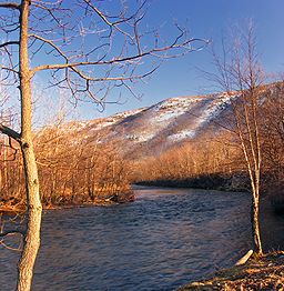
The Lehigh River in East Penn Township
|
|
| Country | United States |
|---|---|
| State | Pennsylvania |
| County | Carbon |
| Elevation | 535 ft (163.1 m) |
| Coordinates | 40°44′30″N 75°45′05″W / 40.74167°N 75.75139°WCoordinates: 40°44′30″N 75°45′05″W / 40.74167°N 75.75139°W |
| Area | 22.9 sq mi (59.3 km2) |
| - land | 22.7 sq mi (59 km2) |
| - water | 0.1 sq mi (0 km2), 0.44% |
| Population | 2,881 (2010) |
| Density | 126.9/sq mi (49.0/km2) |
| Timezone | EST (UTC-5) |
| - summer (DST) | EDT (UTC-4) |
| ZIP codes | 18212, 18235, 18211 |
| Area code | 570 and 610 |
|
Location of East Penn Township in Carbon County
|
|
|
Website: eastpenntownship |
|
East Penn Township is a rural township in the rough uplands terrain of the eastern Mahoning Hills area of Carbon County, Pennsylvania, United States; it has a complementary or sister township, West Penn Township, directly to the west in Schuylkill County. The township sits between two ridgelines of the Ridge-and-Valley Appalachians, but with multiple hilltops, its terrain is unlike many nearby valley floors between similar ridgelines. The population was 2,881 at the 2010 United States Census, up from 2,461 at the 2000 census.
The township is located in the southern corner of Carbon County and is bordered by Lehigh County to the south and Schuylkill County to the west. Older USGS topographic maps show the township in a region known as the Mahoning Hills, a geologically chaotic series of hilltops surmounting a long upland more cyclic in altitude than nearby valley bottoms. The township is drained by the Lehigh River, which flows along its northeastern boundary, with the largest tributary in the township being Lizard Creek. The southern boundary of the township follows the crest of Blue Mountain, a prominent ridge that runs across the eastern half of the state and reaches an elevation of 1,680 feet (510 m) in this area. The northern boundary runs near the broader and lower crest of Mahoning Mountain, elevation 1,150 feet (350 m). The valley floor of the township varies in elevation from 480 to 650 feet (150 to 200 m). Villages in the township include Ashfield, Germans, and West Bowmans.
According to the United States Census Bureau, the township has a total area of 22.9 square miles (59.2 km2), of which 22.7 square miles (58.8 km2) is land and 0.1 square miles (0.3 km2), or 0.59%, is water.
...
Wikipedia


