East Gresford, New South Wales
|
East Gresford New South Wales |
|||||||
|---|---|---|---|---|---|---|---|

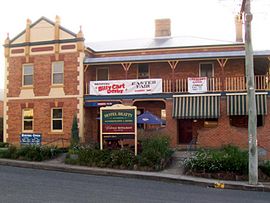
Hotel Beatty, East Gresford
|
|||||||
| Coordinates | 32°25′S 151°34′E / 32.417°S 151.567°ECoordinates: 32°25′S 151°34′E / 32.417°S 151.567°E | ||||||
| Population | 289 (2006 census) | ||||||
| Postcode(s) | 2311 | ||||||
| Elevation | 72 m (236 ft) | ||||||
| Location | |||||||
| LGA(s) | Dungog Shire | ||||||
| State electorate(s) | Upper Hunter | ||||||
| Federal Division(s) | Paterson | ||||||
|
|||||||
East Gresford is a village in the Hunter Region of New South Wales, Australia in Dungog Shire. The village is located 192 kilometres (119 mi) north of Sydney and the nearest major centre is Singleton, some 42 kilometres (26 mi) southwest. In the 2006 census, it had a population of 289.
The traditional owners of the area are the Gringai clan of the Wonnarua people, a group of indigenous people of Australia.
The town is probably named for Gresford in Wales.
There are actually two small villages with the name 'Gresford'. There is Gresford (or West Gresford) on the Singleton side and East Gresford on the Maitland side. It appears that Gresford is the original township, as it is older and the location of the school and local Anglican church. But East Gresford is much larger and has the main shopping area. It is also home to the Gresford Scorpions Soccer Club.
East Gresford is close to the Barrington Tops National Park, which includes the highest peak in the Hunter Valley and is a World Heritage site. It also snows in the area each winter.
In 2017 the annual Gresford Show was held on 10 & 11 March. The highly successful Gresford Billycart Derby occurred on Easter Saturday, 15 April.
More information and updates on activities can also be obtained from the monthly publication of the Gresford News which is also available on-line.
...
Wikipedia

