East Franklin Township, Armstrong County, Pennsylvania
| East Franklin Township, Pennsylvania | |
|---|---|
| Township | |

Along Butler Road in the western part of the township
|
|
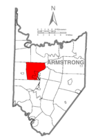
 Map of Armstrong County, Pennsylvania highlighting East Franklin Township |
|
 Map of Armstrong County, Pennsylvania |
|
| Country | United States |
| State | Pennsylvania |
| County | Armstrong |
| Settled | 1830 |
| Incorporated | 1868 |
| Area | |
| • Total | 31.5 sq mi (81.7 km2) |
| • Land | 30.9 sq mi (80.0 km2) |
| • Water | 0.7 sq mi (1.7 km2) |
| Population (2010) | |
| • Total | 4,082 |
| • Density | 132/sq mi (51.0/km2) |
| Time zone | Eastern (EST) (UTC-5) |
| • Summer (DST) | EDT (UTC-4) |
| ZIP code | 16201 |
| Area code(s) | 724 |
| Website | www |
East Franklin Township is a township in Armstrong County, Pennsylvania, United States. The population was 4,082 at the 2010 census.
The Allegheny River Lock and Dam No. 7 was listed on the National Register of Historic Places in 2000.
The township is located in west-central Armstrong County, on the west side of the Allegheny River. It surrounds the boroughs of West Kittanning and Applewold. Unincorporated communities in the township include West Hills, Walkchalk, Furnace Run, Tarrtown, Bridgeburg, Adrian, and Cowansville.
According to the United States Census Bureau, the township has a total area of 31.5 square miles (81.7 km2), of which 30.9 square miles (80.0 km2) is land and 0.66 square miles (1.7 km2), or 2.12%, is water.
As of the census of 2000, there were 3,900 people, 1,546 households, and 1,167 families residing in the township. The population density was 126.4 people per square mile (48.8/km²). There were 1,656 housing units at an average density of 53.7/sq mi (20.7/km²). The racial makeup of the township was 98.87% White, 0.10% African American, 0.21% Native American, 0.36% Asian, 0.03% Pacific Islander, 0.03% from other races, and 0.41% from two or more races. Hispanic or Latino of any race were 0.44% of the population.
...
Wikipedia
