Earlwood
|
Earlwood Sydney, New South Wales |
|||||||||||||
|---|---|---|---|---|---|---|---|---|---|---|---|---|---|

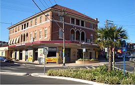
Earlwood Hotel, Homer Street
|
|||||||||||||
| Population | 16,753 (2011 census) | ||||||||||||
| Established | 1829 | ||||||||||||
| Postcode(s) | 2206 | ||||||||||||
| Location | 12 km (7 mi) South of Sydney CBD | ||||||||||||
| LGA(s) | Canterbury-Bankstown Council | ||||||||||||
| State electorate(s) | Canterbury | ||||||||||||
| Federal Division(s) | Barton | ||||||||||||
|
|||||||||||||
Earlwood is a suburb of Sydney, in the state of New South Wales, Australia. Earlwood is located 12 kilometres south of the Sydney central business district, in the local government area of the Canterbury-Bankstown Council. Since the 1960s, the area has been strongly associated with Greece and Greek culture.
Earlwood stretches from the southern bank of the Cooks River to the northern bank of Wolli Creek. Marrickville is located to the east across Cooks River. Earlwood is primarily residential with some commercial developments around the main road, Homer Street.
Earlwood began as a land grant obtained by John Parkes in 1827. John Parkes and his sons operated logging camp called Parkes Camp in 1829 and felled the timber on his 50-acre grant. Later it became known as Parkestown. The name was changed to Forest Hill around 1905-06 and changed again to Earlwood in 1918. 'Earl' reportedly commemorated a former mayor of Canterbury and 'Wood' was the name of two brothers who owned a pig and poultry farm on Wolli Creek. The 'Earlwood' estate was a subdivision in the area of Earlwood Primary or Public School.
Early residents included F. and A. Martin who were granted land in the eastern part, and Joshua Thorpe, architect and Assistant Colonial Engineer, whose 80-acre (32 ha) estate was in the west, stretching from Cooks River to Wolli Creek. In 1828, Joshua Thorp built a house he called Juhan Munna, an Aboriginal phrase meaning "to go away." The house was later renamed Undecliffe and rented to managers of the Canterbury Sugarworks. The property was bought by the solicitor P.A.Tompson in 1850. In 1854, Tompson built a bridge on the site of Thorp's punt.
Frederick Wright Unwin, solicitor and director of the Australasian Sugar Company, obtained land in the Undercliffe area, east of Thorp's property, in 1840, and built his home, which he called Wanstead. Initially, a punt was used to cross the Cooks River. Later, a wooden bridge was built and the road eventually became known as Unwins Bridge Road. The name of the property survives in Wanstead Avenue and Wanstead Reserve. Abraham B. Pollack acquired eight grants in the 1830s, totalling 790 acres (320 ha), which covered most of Earlwood and Undercliffe. Subdivision began in the 1880s.
...
Wikipedia
