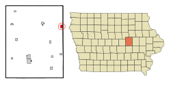
Dysart, Iowa
| Dysart, Iowa | |
|---|---|
| City | |
 Location of Dysart, Iowa |
|
| Coordinates: 42°10′8″N 92°18′29″W / 42.16889°N 92.30806°WCoordinates: 42°10′8″N 92°18′29″W / 42.16889°N 92.30806°W | |
| Country |
|
| State |
|
| County | Tama |
| Area | |
| • Total | 1.25 sq mi (3.24 km2) |
| • Land | 1.25 sq mi (3.24 km2) |
| • Water | 0 sq mi (0 km2) |
| Elevation | 971 ft (296 m) |
| Population (2010) | |
| • Total | 1,379 |
| • Estimate (2012) | 1,367 |
| • Density | 1,103.2/sq mi (425.9/km2) |
| Time zone | Central (CST) (UTC-6) |
| • Summer (DST) | CDT (UTC-5) |
| ZIP code | 52224 |
| Area code(s) | 319 |
| FIPS code | 19-23160 |
| GNIS feature ID | 0456087 |
 |
|
| Type | Weekly newspaper |
|---|---|
| Format | Broadsheet |
| Owner(s) | Marshalltown Newspapers, Inc. |
| Headquarters | 317 Main St., Dysart, Iowa, 52224 USA |
| Circulation | 900 |
| Website | http://www.dysartreporter.com |
Dysart is a city in Tama County, Iowa, United States. The population was 1,379 at the 2010 census. The Mayor of Dysart is currently Pamela Thiele.
Dysart had its start in the year 1872 by the building of the Burlington, Cedar Rapids and Northern Railway through that territory. The town takes its name from Joseph Dysart, a farmer and founder of the town.
Dysart is located at 42°10′8″N 92°18′29″W / 42.16889°N 92.30806°W (42.168831, -92.308165).
According to the United States Census Bureau, the city has a total area of 1.25 square miles (3.24 km2), all of it land.
As of the census of 2010, there were 1,379 people, 544 households, and 380 families residing in the city. The population density was 1,103.2 inhabitants per square mile (425.9/km2). There were 598 housing units at an average density of 478.4 per square mile (184.7/km2). The racial makeup of the city was 97.6% White, 0.5% African American, 0.1% Native American, 0.2% Asian, 0.4% from other races, and 1.2% from two or more races. Hispanic or Latino of any race were 1.5% of the population.
...
Wikipedia
