Dur-Katlimmu

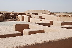
Ruins of the "Red House" of Tell Sheikh Hamad exposed by excavations (6th century AD)
|
|
| Location | Syria |
|---|---|
| Region | Al-Hasakah Governorate |
| Coordinates | 35°38′36″N 40°44′25″E / 35.64333°N 40.74028°ECoordinates: 35°38′36″N 40°44′25″E / 35.64333°N 40.74028°E |
Tell Sheikh Hamad (Arabic: تل الشيخ حمد) is an archeological site in eastern Syria on the lower Khabur River, a tributary of the Euphrates. In the 10th to 7th centuries BC, it was the site of the Assyrian city of Dur-Katlimmu, which may have been founded during the reign of Shalmaneser I. The name Dur-Katlimmu may refer to the limmu (an appointed royal official) Ina-Aššur-šuma-asbat son of Aššur-nadin-šume.
During the fall of the Assyrian Empire (911-605 BC), sections of the Assyrian army retreated to the western corner of Assyria after the fall of Nineveh, Harran and Carchemish, and a number of Assyrian imperial records survive between 604 BC and 599 BC in and around Dur-Katlimmu, and so it is possible that remnants of the Assyrian administration and army still continued to hold out in the region for a few years.
Excavations have recovered 550 cuneiform Akkadian and 40 Aramaic texts belonging to a senior guard of Ashurbanipal.
After the fall of the Assyrian Empire, Dur-Katlimmu became one of the many Near- and Middle-Eastern cities called Magdalu/Magdala//Makdala/, all of which are simply Semitic language toponyms meaning "fortified elevation, tower".
...
Wikipedia

