Dundry
| Dundry | |
|---|---|
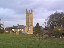
 Dundry church |
|
| Dundry shown within Somerset | |
| Population | 829 |
| OS grid reference | ST555665 |
| Unitary authority | |
| Ceremonial county | |
| Region | |
| Country | England |
| Sovereign state | United Kingdom |
| Post town | BRISTOL |
| Postcode district | BS41 |
| Dialling code | 0117 |
| Police | Avon and Somerset |
| Fire | Avon |
| Ambulance | South Western |
| EU Parliament | South West England |
| UK Parliament | |
Dundry is a village and civil parish, situated on Dundry Hill in the northern part of the Mendip Hills, between Bristol and the Chew Valley Lake, in the English county of Somerset. The parish includes the hamlets of Maiden Head and East Dundry. The parish had a 2011 population of 829.
The village lies on the route of the Monarch's Way long-distance footpath.
According to Robinson the name means 'The hill that is dry' from the Old English dun and dryge. An alternative derivation is from a Celtic name, meaning fort of refuge.
The parish was part of the hundred of Chew.
Dundry is notable for its stone: the yellow oolitic limestone from local quarries such as Dundry Main Road South Quarry and the Dundry Downs (to the west of the village) is found even at Cardiff Castle, a fort originally built by the Romans to defend against Anglo-Saxon invasions. The stone was much used in medieval Bristol: an outstanding example being St Mary Redcliffe, an Anglican church in central Bristol. A large cube of stone (approximately 1.5m each edge) still stands in the churchyard: the cube is much considered to be an early advertisement for Dundry stone.
The neighbouring village of Chew Magna has in its graveyard an early 19th-century limestone round-topped stone which bears the inscription to William Fowler "shot by an Highwayman on Dundry Hill 14 June 1814 aged 32 years".
...
Wikipedia

