Dufur, Oregon
| Dufur, Oregon | |
|---|---|
| City | |

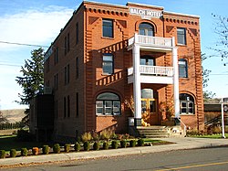
The Balch Hotel in Dufur
|
|
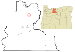
 Location in Oregon |
|
| Coordinates: 45°27′12″N 121°7′38″W / 45.45333°N 121.12722°WCoordinates: 45°27′12″N 121°7′38″W / 45.45333°N 121.12722°W | |
| Country | United States |
| State | Oregon |
| County | Wasco |
| Incorporated | 1893 |
| Government | |
| • Mayor | Robert Wallace |
| Area | |
| • Total | 0.58 sq mi (1.50 km2) |
| • Land | 0.58 sq mi (1.50 km2) |
| • Water | 0 sq mi (0 km2) |
| Elevation | 1,345 ft (410 m) |
| Population (2010) | |
| • Total | 604 |
| • Estimate (2012) | 609 |
| • Density | 1,041.4/sq mi (402.1/km2) |
| Time zone | Pacific (UTC-8) |
| • Summer (DST) | Pacific (UTC-7) |
| ZIP code | 97021 |
| Area code(s) | 458 and 541 |
| FIPS code | 41-20900 |
| GNIS feature ID | 1120201 |
| Website | cityofdufur.org |
Dufur is a city in Wasco County, Oregon, United States. The population was 604 at the 2010 census. It is a farming community where wheat, tree fruit, and grapes are important crops.
Dufur was incorporated on February 10, 1893, and named after Andrew Dufur and his brother Enoch Burnham Dufur. In 1859 they began raising stock on 600 acres (2.4 km2) of land located where the city now stands.
On the second full weekend of August, Dufur holds its annual Threshing Bee, a harvest festival celebrating the local agricultural economy. The festival includes demonstrations of horse-drawn harvesting equipment, and a steam tractor that powers a belt-driven threshing machine.
The historical society is well organized, museum complex for visiting.
According to the United States Census Bureau, the city has a total area of 0.58 square miles (1.50 km2), all of it land.
This region experiences warm (but not hot) and dry summers, with no average monthly temperatures above 68 °F. According to the Köppen Climate Classification system, Dufur has a warm-summer Mediterranean climate, abbreviated "Csb" on climate maps.
As of the census of 2010, there were 604 people, 244 households, and 163 families residing in the city. The population density was 1,041.4 inhabitants per square mile (402.1/km2). There were 263 housing units at an average density of 453.4 per square mile (175.1/km2). The racial makeup of the city was 94.5% White, 1.7% Native American, 0.2% Asian, 0.2% Pacific Islander, 1.3% from other races, and 2.2% from two or more races. Hispanic or Latino of any race were 1.5% of the population.
...
Wikipedia
