Dublin Mountains
| Wicklow Mountains | |
|---|---|
| Cualu | |

Tonelagee mountain in the Glendasan valley, Wicklow Mountains
|
|
| Highest point | |
| Peak | Lugnaquilla |
| Elevation | 925 m (3,035 ft) |
| Coordinates | 52°57′57″N 6°27′46″W / 52.96583°N 6.46278°W |
| Naming | |
| Native name | Sléibhte Chill Mhantáin |
| Geography | |
| Country | Ireland |
| Province | Leinster |
| Counties | Wicklow, Dublin, Wexford and Carlow |
| Range coordinates | 53°04′52″N 6°23′24″W / 53.08111°N 6.39000°WCoordinates: 53°04′52″N 6°23′24″W / 53.08111°N 6.39000°W |
| Parent range | Leinster Chain |
| Borders on | Blackstairs Mountains |
| Geology | |
| Orogeny | Caledonian |
| Age of rock | Cambrian to Devonian, |
| Type of rock | Granite, mica-schist, quartzite |
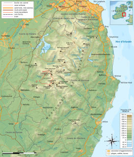
The Wicklow Mountains (Irish: Sléibhte Chill Mhantáin,archaic: Cualu) form the largest continuous upland area in Ireland. They occupy the whole centre of County Wicklow and stretch outside its borders into Counties Dublin, Wexford and Carlow. Where the mountains extend into County Dublin, they are known locally as the Dublin Mountains (Irish: Sléibhte Bhaile Átha Cliath). The highest peak is Lugnaquilla at 925 metres (3,035 feet).
The mountains are primarily composed of granite surrounded by an envelope of mica-schist and much older rocks such as quartzite. They were pushed up during the Caledonian orogeny at the start of the Devonian period and form part of the Leinster Chain, the largest continuous area of granite in Ireland and Britain. The mountains owe much of their present topography to the effects of the last ice age, which deepened the valleys and created corrie and ribbon lakes. Copper and lead have been the main metals mined in the mountains and a brief gold rush occurred in the 18th century. Several major river systems have their source in the mountains, such as the Liffey, Dargle, Slaney and Avoca rivers. Powerscourt Waterfall is the tallest in Ireland at 121 metres (397 feet). A number of these rivers have been harnessed to create reservoirs for drinking water for Dublin and its surroundings.
...
Wikipedia

