Dubh Artach
| Gaelic name | Dubh Artach |
|---|---|
| Meaning of name | The Black Rock |
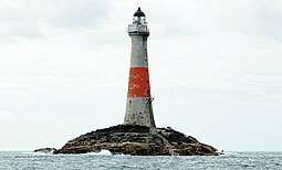
 Dubh Artach skerry and lighthouse in 2014 |
|
| Location | |
|
Dubh Artach shown within Argyll and Bute
|
|
| OS grid reference | NM119030 |
| Coordinates | 56°08′N 6°38′W / 56.13°N 6.63°W |
| Physical geography | |
| Island group | Isle of Mull |
| Area | c.32,300 square feet (3,000 m2) |
| Highest elevation | 36 feet (11 m) |
| Administration | |
| Sovereign state | United Kingdom |
| Country | Scotland |
| Council area | Argyll and Bute |
| Demographics | |
| Population | 0 |
| References | |
| Location | Dhu Heartach skerry 18 miles (29 km) west of Colonsay, Argyll, Scotland |
|---|---|
| Coordinates | 56°08′00″N 6°38′00″W / 56.13333°N 6.63333°WCoordinates: 56°08′00″N 6°38′00″W / 56.13333°N 6.63333°W |
| Year first constructed | 1872 |
| Automated | 1971 |
| Construction | granite tower |
| Tower shape | tapered cylindrical tower with balcony and lantern incorporating keeper's quarter |
| Markings / pattern | white tower with red horizontal band, black lantern |
| Height | 38 metres (125 ft) |
| Focal height | 44 metres (144 ft) |
| Light source | solar power |
| Range | 20 nautical miles (37 km; 23 mi) |
| Characteristic | Fl (2) W 30s. |
| Admiralty number | A4098 |
| NGA number | 4000 |
| ARLHS number | SCO-060 |
| Managing agent |
Northern Lighthouse Board |
Dubh Artach (/duːˈɑːrtɑːx/; Scottish Gaelic: [t̪uh arˠʃt̪əx]) is a remote skerry of basalt rock off the west coast of Scotland lying 18 miles (29 km) west of Colonsay and 15 miles (24 km) south-west of the Ross of Mull.
A lighthouse designed by Thomas Stevenson with a tower height of 145 feet (44 m) was erected between 1867 and 1872 with a shore station constructed on the isle of Erraid. The rock is subject to extraordinary sea conditions with waves of 92 feet (28 m) or more being encountered by the keepers. Despite these adverse conditions several men served the light for lengthy periods until it was automated in 1971.
Dubh Artach is the official name of the lighthouse, although the skerry itself is also known as Dhu Heartach. Various interpretations have been provided for the original meaning of the Gaelic name, of which "The Black Rock" is the most likely.
In pre-historic times Dhu Heartach was covered by the ice sheets that spread from Scotland out into the Atlantic Ocean beyond the Outer Hebrides. After the last retreat of the ice around 20,000 years ago, sea levels were up to 425 feet (130 m) lower than at present. Although the isostatic rise of land makes estimating post-glacial coastlines a complex task, circa 14,000 BP it is likely that Dubh Heartach was at the western edge of a large land bridge linking what is now the island of Ireland to Scotland. This land mass included the islands of Jura and Islay and was probably connected to the mainland of Scotland by an isthmus near Loch Craignish, south of Oban.
...
Wikipedia

