Drangedal
| Drangedal kommune | |||
|---|---|---|---|
| Municipality | |||
 |
|||
|
|||
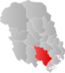
 Drangedal within Telemark |
|||
| Coordinates: 59°7′24″N 8°58′55″E / 59.12333°N 8.98194°ECoordinates: 59°7′24″N 8°58′55″E / 59.12333°N 8.98194°E | |||
| Country | Norway | ||
| County | Telemark | ||
| District | Grenland | ||
| Administrative centre | Prestestranda | ||
| Government | |||
| • Mayor (2016) | Tor Peder Lohne (Ap) | ||
| Area | |||
| • Total | 1,063 km2 (410 sq mi) | ||
| • Land | 996 km2 (385 sq mi) | ||
| Area rank | 96 in Norway | ||
| Population (2016) | |||
| • Total | 4,136 | ||
| • Rank | 223 in Norway | ||
| • Density | 4/km2 (10/sq mi) | ||
| • Change (10 years) | -2.7 % | ||
| Demonym(s) | Drangedøl | ||
| Time zone | CET (UTC+1) | ||
| • Summer (DST) | CEST (UTC+2) | ||
| ISO 3166 code | NO-0817 | ||
| Official language form | Neutral | ||
| Website | www |
||
|
|
|||
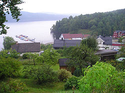
Drangedal is a municipality in Telemark county, Norway. It is part of the traditional region of Grenland. The administrative centre of the municipality is the village of Prestestranda. The municipality of Drangedal was established on 1 January 1838 (see formannskapsdistrikt). The district of Tørdal encompassed the northwestern part of the municipality.
The administrative centre in Drangedal, Prestestranda, and is situated by lake Tokevann. The municipal government is located there along with primary and secondary schools, shopping facilities, and a bank. Drangedal railway station is also located in Prestestranda and is served by the Oslo to Kristiansand Sørlandsbannen railway line.
Alpine and cross-country skiing is possible in the area of Drangedal, at Telemark's largest ski resort.
The Old Norse form of the name was Drangadalr. The first element is probably the genitive plural of drangr m 'mountain peak'. The last element is dalr m 'valley, dale'.
The coat-of-arms is from modern times. They were granted 1989. The arms show two gold-colored pine cones on a green background.
...
Wikipedia


