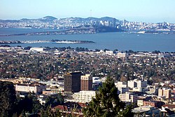
Downtown Berkeley, Berkeley
| Downtown Berkeley | |
|---|---|
| Neighborhood of Berkeley | |

Downtown Berkeley in the foreground, with San Francisco seen across the Bay
|
|
| Location within Berkeley and the East Bay | |
| Coordinates: 37°52′12″N 122°16′05″W / 37.87°N 122.268°W | |
| Country | United States |
| State | California |
| County | Alameda |
| City | Berkeley |
Downtown Berkeley is the central business district of the city of Berkeley, California, United States, around the intersection of Shattuck Avenue and Center Street, and extending north to Hearst Avenue, south to Dwight Way, west to Martin Luther King Jr. Way, and east to Oxford Street. Downtown is the mass transit hub of Berkeley, with several AC Transit and UC Berkeley bus lines converging on the city's busiest BART station, as well as the location of Berkeley's civic center, high school, and Berkeley City College.
The area was formerly a settlement site of the Huichin/Chochen band of the Ohlone indigenous people. Artifacts were found in the 1950s during the digging of a basement on Kittredge Street. The site was probably associated with the proximity of Strawberry Creek which ran along what is today's Allston Way. During the days when the land was part of the vast Rancho San Antonio, a ford existed across Strawberry Creek beneath a clump of oak trees at approximately the intersection of Shattuck Avenue and Allston Way. The road or trail which crossed here connected the ranch houses of two of the Peralta brothers, Domingo and Vicente.
Following the Mexican-American War, four Americans laid claim to four equal strips of land in what is now downtown Berkeley, bounded on the north by what is today the alignment of Addison Street, and on the south, by Dwight Way. Among these claimants was Francis K. Shattuck. Shattuck's portion lay west of what is now Shattuck Avenue. He built a house here at the site of what is today the Shattuck Hotel. The county road going to Oakland along his property was informally called "Shattuck's road", but the planners of the College of California dubbed the street "Guyot" on their plat map. That name never caught on and the street name was upgraded to "Shattuck Avenue". In the 1890s, Strawberry Creek was culverted through the downtown section, the oak trees were removed, and Shattuck and University Avenues were improved. Nonetheless, the area developed slowly until about the time of the 1906 San Francisco earthquake, after which it developed rapidly.
...
Wikipedia

