Dover Heights, New South Wales
|
Dover Heights Sydney, New South Wales |
|||||||||||||
|---|---|---|---|---|---|---|---|---|---|---|---|---|---|

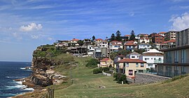
Dover Heights with the Tasman Sea on the left
|
|||||||||||||
| Population | 3,940 (2011 census) | ||||||||||||
| Postcode(s) | 2030 | ||||||||||||
| Location | 9 km (6 mi) from Sydney CBD | ||||||||||||
| LGA(s) | Waverley Council | ||||||||||||
| State electorate(s) | Vaucluse | ||||||||||||
| Federal Division(s) | Wentworth | ||||||||||||
|
|||||||||||||
Dover Heights is a coastal, eastern suburb of Sydney, in the state of New South Wales, Australia. Dover Heights is 9 kilometres east of the Sydney central business district, in the local government area of Waverley Council. Its postcode is 2030.
Dover Heights borders Vaucluse to its north, North Bondi to its south and Rose Bay to its west and has the Pacific Ocean to its east.
Dover Heights is a mainly residential suburb. Many of the suburb's properties have views of Sydney Harbour and the Sydney Harbour Bridge. Its Dudley Page Reserve is a popular site for tourist buses. Some properties have both harbour and ocean views. The Holman House, Dover Heights, was presented the Wilkinson Award by the Royal Australian Institute of Architects in 2005.
The suburb is considered to be the most affluent within the Waverly Local Government Area, and amongst the most affluent suburbs in Sydney. This is reflected in property prices - like nearby suburbs Vaucluse and Bellevue Hill, median house prices are above A$2 million.
Dover Heights is believed to have been named for its cliffs along the Pacific Ocean which resembled those found at Dover, in Kent, England. The first mention of Dover Heights appeared in municipal records in 1886. The area was first used for market gardens.
...
Wikipedia
