Dorogomilovo
| Dorogomilovo District район Дорогомилово (Russian) |
|
|---|---|
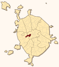
 Location of Dorogomilovo District in Moscow |
|
| Coordinates: 55°44′26″N 37°32′25″E / 55.74056°N 37.54028°ECoordinates: 55°44′26″N 37°32′25″E / 55.74056°N 37.54028°E | |
 Dorogomilovo District |
|
|
|
|
| Location | |
| Country | Russia |
| Federal subject | Moscow |
| Statistics | |
| Population (2010 Census) | 67,720 inhabitants |
| • Urban | 100% |
| • Rural | 0% |
| Time zone | MSK (UTC+03:00) |
| Official website | |
| on | |
Dorogomilovo District (Russian: райо́н Дорогоми́лово) is a district of Western Administrative Okrug of the federal city of Moscow, Russia. Population: 67,720 (2010 Census);59,732 (2002 Census). Postal codes: 113000 to 119000.
The district, adjacent to Presnensky, Arbat, and Khamovniki Districts of Central Administrative Okrug, contains a prestigious 5-kilometer (3.1 mi) strip of land along Kutuzovsky Prospekt, Victory Park, and Kiyevsky Rail Terminal.
This section is based on P.V.Sytin's "History of Moscow Streets"
Original Dorogomilovo sloboda was located on the opposite (eastern) bank of the Moskva River, between Khamovniki and Novodevichy Monastery. Peasants of this sloboda, personally free, were paying their taxes with Yam (mail coach) service on the old road to Smolensk, the main link between Moscow and Poland. Smolensk was annexed by Moscow in the course of the Russo-Polish War, and as a result the road was straightened and a new river crossing emerged on site of present-day Borodinsky Bridge. Dorogomilovo sloboda relocated to the western bank, to present-day Dorogomilovo. For the next two hundred years, the new and the old settlements shared the same name. The only other settlement on the western bank was a fishing village owned by Patriarch.
...
Wikipedia


