Domburg
| Dom | |||
|---|---|---|---|
| Town | |||

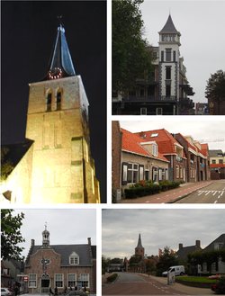
Images from left to right; Old church at night, New small residential tower in the center, street in center, old municipal building, view to center
|
|||
|
|||
 |
|||
 The town centre (dark green) and the statistical district (light green) of Domburg in the municipality of Veere. |
|||
| Coordinates: 51°33′45″N 3°29′47″E / 51.56250°N 3.49639°ECoordinates: 51°33′45″N 3°29′47″E / 51.56250°N 3.49639°E | |||
| Country | Netherlands | ||
| Province | Zeeland | ||
| Municipality | Veere | ||
| Population (1 January 2010) | |||
| • Total | 1,490 | ||
| Time zone | CET (UTC+1) | ||
| • Summer (DST) | CEST (UTC+2) | ||
Domburg is a seaside resort on the North Sea, on the northwest coast of Walcheren in the Dutch province of Zeeland. It is a part of the municipality of Veere, and lies about 11 km northwest of the city of Middelburg, the provincial capital.
In 2010, the town of Domburg had 1,490 inhabitants, up from 1,251 in 2001. The built-up area of the town was 0.78 km², and contained 881 residences.
The area of Domburg has been inhabited since ancient times. In 1647 after heavy storms on the beach of Domburg a sanctuary was discovered with around 40 stones with Latin inscriptions and carvings of several gods, among them of Neptune (sea) and Mercury (trade), but the majority of a local female deity: Nehalennia who appears to have protected both trade and shipping. According to the inscriptions the stones were erected by tradesmen and captains to fulfil their vows after a safe journey, mentioning explicitly on one stone a merchant of pottery doing business with Britain.
From a later period (starting 650 AD) many coins have been found on the beach including Anglo-Saxon sceattas. The settlement on the exact present day location of Domburg however originates from a circular earthen citadel that was discovererd according to expectations by archaeologists in 1991 and which was dated to around 875 AD a period shortly after recorded raids by Danes.
In the following centuries there would be considerable activity by monks, not in the least because of salt works and the reclamation of land by which the island of Walcheren was formed. Near Domburg the mediaeval castle of Westhove, now a family hostel, used to be a stronghold of the abbot of the Abbey of Middelburg.
The town of Domburg, actually more a village, surprisingly received a city charter at the early date of 1223. Probably because the counts of Holland had to seek refuge on the island in some neighbourly quarrel. Until the 19th century the town did not change much in its agricultural and (some) fishing character, although tourism started in the 17th century with cityfolk from Middelburg who would enjoy a Sunday trip to the area in summer because of its coast and woodlands and merry inns. Wealth from both West- and East Indian trade also enabled many merchants from Middelburg and Flushing to build manorhouses with lavish gardens in the area, but only a few have survived.
...
Wikipedia


