Dolgelley Grammar School
| Dolgellau | |
|---|---|
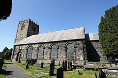
 St Mary's Church, Dolgellau |
|
| Dolgellau shown within Gwynedd | |
| Population | 2,688 (2011 census) |
| OS grid reference | SH728178 |
| Community |
|
| Principal area | |
| Ceremonial county | |
| Country | Wales |
| Sovereign state | United Kingdom |
| Post town | DOLGELLAU |
| Postcode district | LL40 |
| Dialling code | 01341 |
| Police | North Wales |
| Fire | North Wales |
| Ambulance | Welsh |
| EU Parliament | Wales |
| UK Parliament | |
| Welsh Assembly | |
Dolgellau (Welsh pronunciation: [dɔlˈɡɛɬaɨ]; formerly Dolgell(e)y [dɔlˈɡɛɬi]; see below) is a market town in Gwynedd, north-west Wales, lying on the River Wnion, a tributary of the River Mawddach. It is traditionally the county town of the historic county of Merionethshire (Welsh: Meirionnydd, Sir Feirionnydd), which lost its administrative status when Gwynedd was created in 1974. Dolgellau is the main base for climbers of Cader Idris.
The site of Dolgellau was, in the pre-Roman Celtic period, part of the tribal lands of the Ordovices, who were conquered by the Romans in AD 77–78. Although a few Roman coins from the reigns of Emperors Hadrian and Trajan have been found near Dolgellau, the area is marshy and there is no evidence that it was settled during the Roman period. There are, however, three hill forts in the vicinity of Dolgellau, of uncertain origin.
After the Romans left, the area came under the control of a series of Welsh chieftains, although Dolgellau was probably not inhabited until the late 11th or 12th century, when it was established as a "serf village" (or maerdref), possibly by Cadwgan ap Bleddyn — it remained a serf village until the reign of Henry Tudor (1485–1509).
...
Wikipedia

