Dokdo
| Disputed islands Other names: Dokdo, Takeshima, Tok Islets |
|
|---|---|

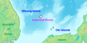
Location of the Liancourt Rocks in the Sea of Japan between South Korea and Japan
|
|
| Geography | |
 |
|
| Location | Sea of Japan |
| Coordinates | 37°14′30″N 131°52′0″E / 37.24167°N 131.86667°E |
| Total islands | 90 (37 permanent land) |
| Major islands | East Islet, West Islet |
| Area | 18.745 hectares (46.32 acres) East Islet: 7.33 hectares (18.1 acres) West Islet: 8.864 hectares (21.90 acres) |
| Highest point |
|
| Administered by | |
| South Korea | |
| County | Ulleung County, North Gyeongsang |
| Claimed by | |
| South Korea | |
| County | Ulleung County, North Gyeongsang |
| Japan | |
| Town | Okinoshima, Shimane |
| Demographics | |
| Population | 50 |
The Liancourt Rocks, also known as Dokdo or Tokto (Korean pronunciation: [tokt͈o]; Hangul: 독도; Hanja: 獨島, "solitary island") in Korean, and Takeshima (竹島, "bamboo island") in Japanese, are a group of small islets in the Sea of Japan. While South Korea controls the islets, its sovereignty over them is contested by Japan. South Korea classifies the islets as Dokdo-ri, Ulleung-eup, Ulleung County, North Gyeongsang Province. Japan classifies them as part of Okinoshima, Oki District, Shimane Prefecture.
The Franco-English name of the islets derives from Le Liancourt, the name of a French whaling ship which came close to being wrecked on the rocks in 1849.
The Liancourt Rocks consist of two main islets and 35 smaller rocks; the total surface area of the islets is 0.18745 square kilometres (46.32 acres), with the highest elevation of 169 metres (554 ft) found at an unnamed location on the West Islet.
The Liancourt Rocks lie in rich fishing grounds which may contain large deposits of natural gas.
The Liancourt Rocks consist of two main islets and numerous surrounding rocks. The two main islets, called Seodo (Hangul: 서도; Hanja: 西島, "Western Island") and Dongdo (Hangul: 동도; Hanja: 東島, "Eastern Island") in Korean, and Ojima (男島, "Male Island") and Mejima (女島, "Female Island") in Japanese, are 151 metres (495 ft) apart. The Western Island is the larger of the two, with a wider base and higher peak, while the Eastern Island offers more usable surface area.
...
Wikipedia
