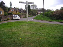
Dodford, Northamptonshire
| Dodford | |
|---|---|
 Dodford within Daventry District |
|
| Dodford shown within Northamptonshire | |
| Population | 203 (2011 Census) |
| OS grid reference | SP613605 |
| • London | 73.6 |
| District | |
| Shire county | |
| Region | |
| Country | England |
| Sovereign state | United Kingdom |
| Post town | DAVENTRY |
| Postcode district | NN7 |
| Dialling code | 01327 |
| Police | Northamptonshire |
| Fire | Northamptonshire |
| Ambulance | East Midlands |
| EU Parliament | East Midlands |
| UK Parliament | |
Dodford is a village in the county of Northamptonshire, England, within the Weedon Ward of Daventry District. The village is just north of the A45 road 1½ miles west of Weedon. The population of the civil parish at the 2011 Census was 203. It is 3½ miles east of Daventry and ten miles west of Northampton. It is also close to junction 16 of the M1 motorway. The parish consists of some 1,384 acres (560 hectares) and is bounded on the east by the A5 trunk road which is the old Roman road of Watling Street. Most of the village and parish sits astride the valley of an east-flowing stream which is a tributary of the River Nene.
There are considerable earthworks around the village on the northern side of the stream, which indicate that Dodford was a larger settlement than it is today. Many of these earthworks have been ploughed out in recent years, but the evidence has been recorded of their existence. These earthworks suggest that there was a large scale de-population or a considerable movement of the village. Dodford is mentioned in an Anglo-Saxon charter of 944. The village is recorded in the Domesday Book as a manor of three hides belonging to Robert, Count of Mortain (who was the half-brother of William the Conqueror), with a recorded population of 22 including a priest. In 1222 the manor of Dodford was acquired by William de Keynes who enclosed much of the land including a deer park which lay to the south of the village between it and what is now the A45 between Daventry and Weedon. In 1673 it is recorded that 39 people paid Hearth Tax. By the early part of the 18th century there were 21 dwellings in the village and a map dated 1742 shows the layout of the village much as it is today. In 1801 the village is recorded as having 205 residents.
...
Wikipedia

