Dochula Pass
| Dochula Pass | |
|---|---|

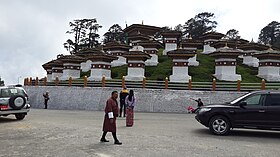
Dochula pass with 108 stupas or chortens in Thimpu on the east west road
|
|
| Elevation | 3,100 m (10,171 ft) |
| Location | East-West Road from Thimpu to Punakha 27°29'24"N 89°45'1"E |
| Range | Himalayas |
| Coordinates | 27°29′24″N 89°45′01″E / 27.49000°N 89.75028°ECoordinates: 27°29′24″N 89°45′01″E / 27.49000°N 89.75028°E |
The Dochula Pass is a mountain pass in the snow covered Himalayas within Bhutan on the road from Thimpu to Punakha where 108 memorial chortens or stupas known as "Druk Wangyal Chortens" have been built by Ashi Dorji Wangmo Wangchuk, the eldest Queen Mother. Apart from the chortens there is a monastery called the Druk Wangyal Lhakhang (temple), built in honour of the fourth Druk Gyalpo (head of the state of Bhutan), Jigme Singye Wangchuck; the open grounds in its front yard is a venue for the annual Dochula Druk Wangyel Festival. The pass with 108 memorial chortens is adjacent to the country's first Royal Botanical Park.
The pass is located at an elevation of 3,100 metres (10,200 ft) (3,140 metres (10,300 ft) and 3,150 metres (10,330 ft) are also mentioned) on the East West Road from Thimpu to Punakha and further east in the Himalayas amidst the Eastern Himalayan snow-covered mountains. To the east of the pass, the snow clad mountain peaks of the Himalayas are seen prominently and among them is the Mt. Masanggang at 7,158 metres (23,484 ft) which is the highest peak in Bhutan, known in local language as the Mt. Gangkar Puensum. The road east of the pass runs steep for some distance and then takes a left turn towards Punakha Valley to the Punakha Dzong, in Punakha (the old capital of Bhutan), which is located at the confluence of two rivers. Further east the road reaches Wangdi Phodrong where there a 7th-century monastery on the ridge, and the valley is drained by the Punatsangchu River. The pass was part of ancient trails or tracks between Thimphu and Punakha, such as the Dochu La Nature Trail (1.2 kilometres (0.75 mi)) which begins at the Dochu La cafe and meets the present road at Lamperi, and the Lumitsawa Ancient Trail (4.7 kilometres (2.9 mi)) that joins the main road at Lumitsawa. Both trails are sections of the original route.
The weather at the pass generally remains foggy and chilly. However, between October and February, panoramic views of the Bhutan Himalayas can be seen.
...
Wikipedia

