Dobrinja
| Dobrinja | |
|---|---|
| Neighborhood | |

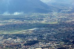
Dobrinja and Sarajevo Airport as seen from Mount Trebević
|
|
| Country | Bosnia and Herzegovina |
| Entity | Federation of Bosnia and Herzegovina |
| Time zone | CET (UTC+1) |
| • Summer (DST) | CEST (UTC+2) |
Coordinates: 43°49′41″N 18°20′49″E / 43.828°N 18.347°E
Dobrinja is a neighbourhood of Sarajevo, in the western outskirts of the town, part of the municipality of Novi Grad. It is estimated to host 40,000 inhabitants. Its name comes from the short river Dobrinja that crosses it. It is today organised in four communities (MZ Dobrinja A, B, C, and D). Dobrinja lies just north of the Sarajevo International Airport.
The first phase of settlement construction was completed in 1983 with the settlement areas of Dobrinja I and Dobrinja II, used as olympic village for the accommodation of sportspeople and foreign journalists in Sarajevo for the 1984 Winter Olympics. They included two residential neighborhood, one school, and a trolleybus line to link it with the city centre. Dobrinja III, with its primary school, was the next phase in the second half of the 1980s. By the early 1990s Dobrinja IV and V were built and occupied. The newest blocks. These newest settlements suffered most damage during the conflict, as they were repeatedly bombed by the Army of Republika Srpska, and all three schools were destroyed. Overall, during the Siege of Sarajevo (1992–95), Dobrinja was the most bombed neighborhood of Sarajevo. In 1993 a mortar attack was conducted from Serb-held positions on a football game. 13 people died and over 130 were wounded.
Most of Dobrinja lies west of the inter-entity boundary line, in the territory of Kanton Sarajevo. Only its eastern settlements (Dobrinja IV and parts of Dobrinja I) are in the territory of Republika Srpska, making up the municipality of Istočno Novo Sarajevo, where lies the East Sarajevo Bus Station (Istočno Sarajevo Autobusna Stanica).
...
Wikipedia
