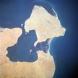
Djerba, Tunisia
 |
|
| Geography | |
|---|---|
| Location | Gulf of Gabès |
| Area | 514 km2 (198 sq mi) |
| Administration | |
| Largest settlement | Houmt El Souk (pop. 75,904) |
| Demographics | |
| Population | 163,726 (2013 Estimate) |
| Pop. density | 309 /km2 (800 /sq mi) |
| Ethnic groups | Berbers, Arabs, Jews and Black African |
Djerba (Arabic: جربة ![]() ˈʒɪrbæ), also transliterated as Jerba or Jarbah, is, at 514 square kilometres (198 sq mi), the largest island of North Africa, located in the Gulf of Gabès, off the coast of Tunisia. It had a population of 139,544 at the 2004 Census, while the latest official estimate (as at 1 July 2014) is 163,726.
ˈʒɪrbæ), also transliterated as Jerba or Jarbah, is, at 514 square kilometres (198 sq mi), the largest island of North Africa, located in the Gulf of Gabès, off the coast of Tunisia. It had a population of 139,544 at the 2004 Census, while the latest official estimate (as at 1 July 2014) is 163,726.
Legend has it that Djerba was the island of the lotus-eaters where Odysseus was stranded on his voyage through the Mediterranean.
The island, which was called Meninx until the third century AD, includes three principal towns. One of these, whose modern name is Būrgū, is found near Midoun in the center of the island. Another city, on the southeast coast of the island at Meninx, was a major producer of priceless murex dye, and is cited by Pliny the Elder as second only to Tyre in this regard. A third important town was the ancient Haribus. The island was densely inhabited in the Roman and Byzantine periods, and probably imported much of the grain consumed by its inhabitants. The island appears on the 4th century Peutinger Map.
During the Middle Ages, Djerba was occupied by Ibadi Muslims, who claimed it as their own. The Christians of Sicily and Aragon disputed this claim with the Ibadites. Remains from this period include numerous small mosques dating from as early as the twelfth century, as well as two substantial forts.
...
Wikipedia

