Djenné
| Djenné | |
|---|---|
| Commune and town | |
 |
|
| Coordinates: 13°54′20″N 4°33′18″W / 13.90556°N 4.55500°WCoordinates: 13°54′20″N 4°33′18″W / 13.90556°N 4.55500°W | |
| Country |
|
| Region | Mopti Region |
| Cercle | Djenné Cercle |
| Area | |
| • Total | 302 km2 (117 sq mi) |
| Elevation | 278 m (912 ft) |
| Population (2009) | |
| • Total | 32,944 |
| • Density | 110/km2 (280/sq mi) |
| Old Towns of Djenné | |
|---|---|
| Name as inscribed on the World Heritage List | |

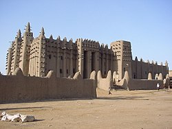
The Great Mosque
|
|
| Location | Mali |
| Type | Cultural |
| Criteria | iii, iv |
| Reference | 116 |
| UNESCO region | Africa |
| Inscription history | |
| Inscription | 1988 (12th Session) |
Djenné (also Djénné, Jenné and Jenne) is a town and an urban commune in the Inland Niger Delta region of central Mali. The town is the administrative centre of the Djenné Cercle, one of the eight subdivisions of the Mopti Region. The commune includes ten of the surrounding villages and in 2009 had a population of 32,944.
The history of Djenné is closely linked with that of Timbuktu. Between the 15th and 17th centuries much of the trans-Saharan trade in goods such as salt, gold and slaves that moved in and out of Timbuktu passed through Djenné. Both towns became centres of Islamic scholarship. Djenné's prosperity depended on this trade and when the Portuguese established trading posts on the African coast, the importance of the trans-Saharan trade and thus of Djenné declined.
The town is famous for its distinctive adobe architecture, most notably the Great Mosque which was built in 1907 on the site of an earlier mosque. To the south of the town is Djenné-Djeno, the site of one of the oldest known towns in sub-Saharan Africa. Djenné together with Djenné-Djeno were designated a World Heritage Site by UNESCO in 1988.
Djenné is situated 398 km (247 mi) northeast of Bamako and 76 km (47 mi) southwest of Mopti. The town sits on the floodplain between the Niger and Bani rivers at the southern end of the Inland Niger Delta. The town has an area of around 70 ha and during the annual floods becomes an island that is accessed by causeways. The Bani river is 5 km (3.1 mi) south of the town and is crossed by ferry.
For administrative purposes the town forms part of the commune of Djenné which covers an area of 302 square kilometers and consists of the town and ten of the surrounding villages: Ballé, Diabolo, Gomnikouboye, Kamaraga, Kéra, Niala, Soala, Syn, Velingara and Yenleda. The population figures are for the commune and include these villages. The commune is bounded to the north by the communes of Ouro Ali and Derary, to the south by the commune of Dandougou Fakala, to the east by the communes of Fakala and Madiama and to the west by the commune of Pondori. The town is the administrative center (chef-lieu) of the Djenné Cercle, one of eight administrative subdivisions of the Mopti Region.
...
Wikipedia

