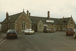
Dingwall railway station
| Dingwall |
|
|---|---|
| Scottish Gaelic: Inbhir Pheofharain | |

Dingwall station in October 1984
|
|
| Location | |
| Place | Dingwall |
| Local authority | Highland |
| Coordinates | 57°35′39″N 4°25′20″W / 57.5942°N 4.4222°WCoordinates: 57°35′39″N 4°25′20″W / 57.5942°N 4.4222°W |
| Grid reference | NH553585 |
| Operations | |
| Station code | DIN |
| Managed by | Abellio ScotRail |
| Number of platforms | 2 |
| Live arrivals/departures, station information and onward connections from National Rail Enquiries |
|
| Annual rail passenger usage* | |
| 2011/12 |
|
| – Interchange |
|
| 2012/13 |
|
| – Interchange |
|
| 2013/14 |
|
| – Interchange |
|
| 2014/15 |
|
| – Interchange |
|
| 2015/16 |
|
| – Interchange |
|
| History | |
| Original company | Inverness and Ross-shire Railway |
| Pre-grouping | Highland Railway |
| Post-grouping | LMS |
| 11 June 1862 | Opened |
| National Rail – UK railway stations | |
| * Annual estimated passenger usage based on sales of tickets in stated financial year(s) which end or originate at Dingwall from Office of Rail and Road statistics. Methodology may vary year on year. | |
|
|
|
Dingwall railway station serves Dingwall, in the Highland council area of Scotland. It is located just south of the junction of the Far North Line and the Kyle of Lochalsh Line, and is served by Abellio ScotRail. A recent increase of services has increased usage dramatically (see figures right).
The station was built by the Inverness and Ross-shire Railway (I&RR) and opened on 11 June 1862 when the company's line was opened from Inverness to Dingwall. The extension to Invergordon came on 23 March 1863. The I&RR was consolidated with the Inverness and Aberdeen Junction Railway on 30 June 1862. The operating name became the Highland Railway (HR) on 29 June 1865. Under Highland Railway ownership the current station buildings were erected in 1886 by architect Murdoch Paterson.
The HR became a constituent of the London Midland and Scottish Railway (LMSR) in 1923.
The main passenger services through the station were to Wick and Thurso and to Kyle of Lochalsh. Between 1885 and 1946 there was a branch line service to Strathpeffer.
The Highland Railway built a small steam locomotive shed near the station and this continued in use by the LMSR and British Railways until closure at the end of steam locomotive operations in the area in the early 1960s. It was a sub-shed of the large Inverness facility.
The station formerly had two signal boxes to supervise the passing loop and junction between the two routes - both were however closed in 1985 when the Radio Electronic Token Block system was introduced by British Rail on the Far North Line. The system was initially worked from a control centre at the station, with the line southwards planned for inclusion in the Inverness area resignalling scheme. However, when the Inverness scheme was completed in 1988, RETB control was transferred to the new signalling centre there and one here was closed. The junction points were altered so that they were (and still are) power operated - drivers of northbound trains use a plunger on the down platform to select the correct route, whilst southbound trains trigger the correct setting by occupying track circuits on the approach to the station.
...
Wikipedia
