Dietzhausen
| Suhl | ||
|---|---|---|

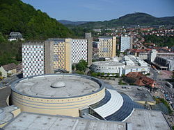
View over Suhl
|
||
|
||
| Coordinates: 50°36′38″N 10°41′35″E / 50.61056°N 10.69306°ECoordinates: 50°36′38″N 10°41′35″E / 50.61056°N 10.69306°E | ||
| Country | Germany | |
| State | Thuringia | |
| District | Urban district | |
| Government | ||
| • Mayor | Jens Triebel (Ind.) | |
| Area | ||
| • Total | 102.70 km2 (39.65 sq mi) | |
| Elevation | 429-676 m (−1,789 ft) | |
| Population (2015-12-31) | ||
| • Total | 36,778 | |
| • Density | 360/km2 (930/sq mi) | |
| Time zone | CET/CEST (UTC+1/+2) | |
| Postal codes | 98501–98530 | |
| Dialling codes | 03681 | |
| Vehicle registration | SHL | |
| Website | www.suhltrifft.de | |
Suhl is a city in Thuringia, Germany, located 50 kilometres (31 miles) SE of Erfurt, 110 kilometres (68 miles) NE of Würzburg and 130 kilometres (81 miles) N of Nuremberg. With its 35,000 inhabitants, it is the smallest of the six urban districts within Thuringia. Together with its northern neighbour-town Zella-Mehlis, Suhl forms the largest urban area in the Thuringian Forest with a population of 46,000. The region around Suhl is marked by up to 1,000-meter high mountains, including Thuringia's highest peak, the Großer Beerberg (983 m), approximately 5 kilometres (3 miles) NE of the city centre.
Suhl was first mentioned in 1318 and stayed a small mining and metalworking town, until industrialization broke through in late 19th century and Suhl became a centre of Germany's arm production, specialized on rifles and guns with companies such as Sauer & Sohn. Furthermore, the engineering industry was based in Suhl with Simson, a famous car and moped producer. In 1952, Suhl became one of East Germany's 14 district capitals, which led to a government-directed period of urban growth and conversion. Its results – a typical 1960s concrete architecture-marked city centre – are defining until today. With the loss of its administrative and industrial functions, Suhl saw a lasting period of urban decline since 1990.
Suhl is known for its sportsmen, especially in shooting, winter sports, and volleyball.
Though first appearing in a 1318 deed, several entrys in the annals of Fulda Abbey already mentioned a place named Sulaha between 900 and 1155 AD. The coat of arms from 1365 shows two hammers, indicating the city's most important livelihood: metal processing. The region belonged to the territories held by the Franconian counts of Henneberg since the 11th century. Suhl was located on an important trade route from Gotha, Erfurt and Arnstadt passing the Thuringian Forest mountain range at Oberhof and continuing to the Henneberg's residence, Schleusingen.
...
Wikipedia


