Diamond Head, Hawaii
| Diamond Head | |
|---|---|

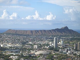
Diamond Head cone seen from Tantalus-Round Top Road
|
|
| Highest point | |
| Elevation | 762 ft (232 m) |
| Prominence | 560 ft (170 m) |
| Coordinates | 21°15′35.0″N 157°48′42.3″W / 21.259722°N 157.811750°WCoordinates: 21°15′35.0″N 157°48′42.3″W / 21.259722°N 157.811750°W |
| Geography | |
| Parent range | Hawaiian Islands |
| Topo map | USGS Honolulu |
| Geology | |
| Age of rock | 200,000 years |
| Mountain type | Volcanic cone |
| Climbing | |
| Easiest route | Trail |
| Designated | 1968 |
Diamond Head is the name of a volcanic tuff cone on the Hawaiian island of Oʻahu and known to Hawaiians as Lēʻahi, most likely from lae 'browridge, promontory' plus ʻahi 'tuna' because the shape of the ridgeline resembles the shape of a tuna's dorsal fin. Its English name was given by British sailors in the 19th century, who mistook calcite crystals on the adjacent beach for diamonds.
Diamond Head is part of the system of cones, vents, and their associated eruption flows that are collectively known to geologists as the Honolulu Volcanic Series, eruptions from the Koʻolau Volcano that took place long after the volcano formed and had gone dormant. The Honolulu Volcanic Series is a series of volcanic eruption events that created many of Oʻahu's well-known landmarks, including Punchbowl Crater, Hanauma Bay, Koko Head, and Mānana Island in addition to Diamond Head.
Diamond Head, like the rest of the Honolulu Volcanic Series, is much younger than the main mass of the Koʻolau Mountain Range. While the Koʻolau Range is about 2.6 million years old, Diamond Head is estimated to be about 500,000 to 400,000 years old.
The interior and adjacent exterior areas were the home to Fort Ruger, the first United States military reservation on Hawaii. Only a National Guard facility and Hawaii State Civil Defense remain in the crater. An FAA air traffic control center was in operation from 1963 to 2001.
...
Wikipedia

