Diacria quadrangle

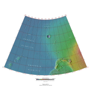
Map of Diacria quadrangle from Mars Orbiter Laser Altimeter (MOLA) data. The highest elevations are red and the lowest are blue.
|
|
| Coordinates | 47°30′N 150°00′W / 47.5°N 150°WCoordinates: 47°30′N 150°00′W / 47.5°N 150°W |
|---|---|
| Eponym | Diacria highlands around Marathon in Greece |
The Diacria quadrangle is one of a series of 30 quadrangle maps of Mars used by the United States Geological Survey (USGS) Astrogeology Research Program. The quadrangle is located in the northwestern portion of Mars’ western hemisphere and covers 180° to 240° east longitude (120° to 180° west longitude) and 30° to 65° north latitude. The quadrangle uses a Lambert conformal conic projection at a nominal scale of 1:5,000,000 (1:5M). The Diacria quadrangle is also referred to as MC-2 (Mars Chart-2). The Diacria quadrangle covers parts of Arcadia Planitia and Amazonis Planitia.
The southern and northern borders of the Diacria quadrangle are approximately 3,065 km (1,905 mi) and 1,500 km (930 mi) wide, respectively. The north to south distance is about 2,050 km (1,270 mi) (slightly less than the length of Greenland). The quadrangle covers an approximate area of 4.9 million square km, or a little over 3% of Mars’ surface area. The Phoenix Lander’s landing site (68.22° N, 234.25° E) lies about 186 km north of the northeastern quarter of the Diacria quadrangle. The landscape viewed by the Phoenix lander is probably representative of a large portion of the terrain in the northern Diacria quadrangle.
Diacria is the name of a telescopic albedo feature located at 48° N and 190° E on Mars. The feature was named by Greek astronomer E. M. Antoniadi in 1930 after Diacria, the highlands around Marathon in north-west Attica, Greece. The name was approved by the International Astronomical Union (IAU) in 1958.
The Diacria quadrangle is located at the northwestern edge of the Tharsis volcanic plateau. Topographic, volcanic, and tectonic features associated with the large volcanoes Olympus Mons (south of map area) and Alba Mons (east of map area) characterize the southeastern and east central portions of the quadrangle. The northern and western areas of the quadrangle lie in the northern lowland plains of Mars and cover portions of Amazonis Planitia (in the south), Arcadia Planitia (west central) and Vastitas Borealis (in the north). The large crater Milankovič (118.4 km in diameter) is located in the north central portion of the quadrangle at 54.7° N, 213.3° E.
...
Wikipedia
