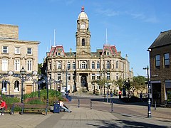
Dewsbury
| Dewsbury | |
|---|---|
 Dewsbury Town Hall |
|
| Dewsbury shown within West Yorkshire | |
| Population | 62,945 (2011 Census) |
| OS grid reference | SE245225 |
| Metropolitan borough | |
| Metropolitan county | |
| Region | |
| Country | England |
| Sovereign state | United Kingdom |
| Post town | DEWSBURY |
| Postcode district | WF12-13 |
| Dialling code | 01924 |
| Police | West Yorkshire |
| Fire | West Yorkshire |
| Ambulance | Yorkshire |
| EU Parliament | Yorkshire and the Humber |
| UK Parliament | |
Dewsbury (/ˈdjuːzbəri/) is a minster town in the Metropolitan Borough of Kirklees, in West Yorkshire, England. It is to the west of Wakefield, east of Huddersfield and south of Leeds. It lies by the River Calder and an arm of the Calder and Hebble Navigation.
Historically a part of the West Riding of Yorkshire, after undergoing a period of major growth in the 19th century as a mill town, Dewsbury went through a period of decline. More recently there has been redevelopment of derelict mills into flats, and regenerating of city areas.
According to the 2011 census the Dewsbury urban sub-area had a population of 62,945. Dewsbury is the largest town in the Heavy Woollen District, a conurbation of small mill towns.
The Domesday Book of 1086 records the name as Deusberie, Deusberia, Deusbereia, or Deubire, literally "Dewi's fort", Dewi being an old Welsh name (equivalent to David) and "bury" coming from the old English word "burh", meaning fort.
Other, less supported, theories exist as to the name's origin. For example, that it means "dew hill", from Old English dēaw (genitive dēawes), "dew", and beorg, "hill" (because Dewsbury is built on a hill). It has been suggested that dēaw refers to the town's proximity to the water of the River Calder.
...
Wikipedia

