Devonport Airport
| Devonport Airport | |||||||||||||||
|---|---|---|---|---|---|---|---|---|---|---|---|---|---|---|---|
| Summary | |||||||||||||||
| Airport type | Public | ||||||||||||||
| Operator | Tasmanian Ports Corporation Pty. Ltd. | ||||||||||||||
| Serves | Devonport, Tasmania, Australia | ||||||||||||||
| Elevation AMSL | 33 ft / 10 m | ||||||||||||||
| Coordinates | 41°10′11″S 146°25′49″E / 41.16972°S 146.43028°ECoordinates: 41°10′11″S 146°25′49″E / 41.16972°S 146.43028°E | ||||||||||||||
| Website | Devonport Airport | ||||||||||||||
| Map | |||||||||||||||
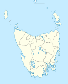
| Location in Tasmania | |||||||||||||||
| Runways | |||||||||||||||
|
|||||||||||||||
| Statistics (2010/11) | |||||||||||||||
|
|||||||||||||||
| Revenue passengers | 139,019 |
|---|---|
| Aircraft movements | 4,416 |
Devonport Airport (IATA: DPO, ICAO: YDPO) is a regional airport serving Devonport, a city in the Australian state of Tasmania. It is located 10 km (6.2 mi) from the town centre at Pardoe Downs, on Wesley Vale and Airport Roads. The airport is operated by the Tasmanian Ports Corporation (Tasports), which previously operated the larger Hobart International Airport.
The airport resides at an elevation of 33 ft (10 m) above sea level. It has two runways: 06/24 with an asphalt surface measuring 1,838 m × 45 m (6,030 ft × 148 ft) and 14/32 with a grass surface measuring 880 m × 30 m (2,887 ft × 98 ft).
Devonport Airport was ranked 40th in Australia for the number of revenue passengers served in financial year 2010-2011.
...
Wikipedia

