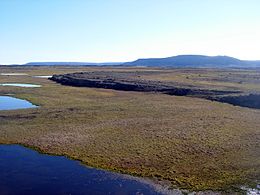
Devon Island
| Native name: Tatlurutit | |
|---|---|

Truelove Lowland, a polar oasis located in Devon Island
|
|
| Geography | |
| Location | Baffin Bay |
| Coordinates | 75°08′N 087°51′W / 75.133°N 87.850°WCoordinates: 75°08′N 087°51′W / 75.133°N 87.850°W |
| Archipelago |
Queen Elizabeth Islands Canadian Arctic Archipelago |
| Area | 55,247 km2 (21,331 sq mi) |
| Area rank | 27th |
| Length | 524 km (325.6 mi) |
| Width | 155–476 km (96–296 mi) |
| Highest elevation | 1,920 m (6,300 ft) |
| Highest point | Devon Ice Cap |
| Administration | |
| Territory | Nunavut |
| Region | Qikiqtaaluk Region |
| Demographics | |
| Population | Uninhabited |
Devon Island (Inuit: Tatlurutit) is the largest uninhabited island on Earth. It is located in Baffin Bay, Qikiqtaaluk Region, Nunavut, Canada. It is one of the larger members of the Canadian Arctic Archipelago, the second-largest of the Queen Elizabeth Islands, Canada's sixth largest island, and the 27th-largest island in the world. It comprises 55,247 km2 (21,331 sq mi) (slightly smaller than Croatia) of Precambrian gneiss and Paleozoic siltstones and shales. The highest point is the Devon Ice Cap at 1,920 m (6,300 ft) which is part of the Arctic Cordillera. Devon Island contains several small mountain ranges, such as the Treuter Mountains, Haddington Range and the Cunningham Mountains.
Robert Bylot and William Baffin were the first Europeans to sight the island in 1616.William Edward Parry charted its south coast in 1819-20, and named it North Devon, after Devon in England, a name which was changed to Devon Island by the end of the 1800s. In 1850 Edwin De Haven sailed up Wellington Channel and sighted the Grinnell Peninsula.
...
Wikipedia

