Devil's Path (hiking trail)
| Devil's Path | |
|---|---|

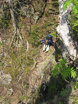
A backpacker negotiates a rock chimney on Indian Head Mountain
|
|
| Length | 24.2 mi (38.9 km) |
| Location | Town of Hunter / Town of Lexington, Greene County, New York, USA |
| Trailheads | Prediger Road (east); Spruceton Road (west) |
| Use | Hiking |
| Elevation | |
| Elevation gain/loss | 9,000 feet (2,700 m) gain approximately |
| Highest point | West Kill Mountain, 3,880 ft (1,180 m) |
| Lowest point | Stony Clove Notch, 2,220 ft (680 m) |
| Hiking details | |
| Trail difficulty | Strenuous |
| Season | all |
| Sights | Northern Catskill Mountains |
| Hazards | Steep, precarious climbs |
The Devil's Path is a hiking trail in the Greene County section of the Catskill Mountains of New York, often described as one of the more challenging trails in the New York Tri-state area. It goes across the eponymous mountain range and then three other peaks to the west, offering hikers and peakbaggers a chance to reach the summits of five of the 35 Catskill High Peaks (two more are reachable by detours). It draws hikers from not just the region but far outside, due to the challenging climbs straight up and down the steep gaps between the four peaks of the range, which often require hikers to use hands as well as feet to pull themselves almost straight up cliffs and through rocky chutes. These climbs, however, lead to many spectacular views of the Catskill range.
Most hikers use the trail for day trips to one or two summits along the range, via the trails that go up into the cols. But backpackers have done weekend trips due to the easy availability of a state-owned campground at Devil's Tombstone, near the single road crossing at Stony Clove Notch. It is also possible for determined hikers to complete the entire trail in a single, long day.
The portion of the trail from Plateau Mountain to just east of Indian Head Mountain is currently part of the Long Path. Most of it is on state-owned Forest Preserve land in New York's Catskill Park. Most of it lies within two New York State Department of Environmental Conservation management units, the Indian Head Wilderness Area east of Stony Clove Notch and (currently) the Hunter Mountain Wild Forest from there to Diamond Notch, then the West Kill Wilderness Area.
...
Wikipedia
