Desha County, Arkansas
| Desha County, Arkansas | |
|---|---|

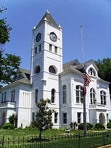
Desha County courthouse in Arkansas City
|
|
 Location in the U.S. state of Arkansas |
|
 Arkansas's location in the U.S. |
|
| Founded | December 12, 1838 |
| Named for | Benjamin Desha |
| Seat | Arkansas City |
| Largest city | Dumas |
| Area | |
| • Total | 820 sq mi (2,124 km2) |
| • Land | 768 sq mi (1,989 km2) |
| • Water | 51 sq mi (132 km2), 6.3% |
| Population (est.) | |
| • (2015) | 11,965 |
| • Density | 17/sq mi (7/km²) |
| Congressional district | 1st |
| Time zone | Central: UTC-6/-5 |
| Website | deshacounty |
Desha County /dəˈʃeɪ/ is a county located in the southeast part of the U.S. state of Arkansas. As of the 2010 census, the population was 13,008, making it the fifty-sixth most populous of Arkansas's seventy-five counties. The county seat is Arkansas City. Located within the Arkansas Delta, Desha County's rivers and fertile soils led to prosperity under the cotton-driven economy of plantation agriculture. Following mechanization on the farm, Desha County saw a demographic and economic transformation. Today, the county seeks to reverse its population and economic losses through better education for its workforce and tourism based on the cultural, historical and outdoor recreation amenities it offers to residents and tourists.
Desha County was created by the Arkansas Legislature on December 12, 1838, consisting of the lands of Arkansas County separated from the county seat by the Arkansas River White River and land from Chicot County. The county was named for Captain Benjamin Desha, who fought in the War of 1812.
According to the U.S. Census Bureau, the county has a total area of 820 square miles (2,100 km2), of which 768 square miles (1,990 km2) is land and 51 square miles (130 km2) (6.3%) is water. Desha County is within the Arkansas Delta and is considered a member of the Southeast Arkansas region.
As of the 2000 United States Census, there were 15,341 people, 5,922 households, and 4,192 families residing in the county. The population density was 20 people per square mile (8/km²). There were 6,663 housing units at an average density of 9 per square mile (3/km²). The racial makeup of the county was 50.50% White, 46.33% Black or African American, 0.35% Native American, 0.30% Asian, 0.03% Pacific Islander, 1.73% from other races, and 0.76% from two or more races. 3.16% of the population were Hispanic or Latino of any race.
...
Wikipedia
