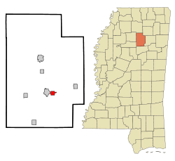
Derma, Mississippi
| Derma, Mississippi | |
|---|---|
| Town | |
 |
|
 Location of Derma, Mississippi |
|
| Location in the United States | |
| Coordinates: 33°51′24″N 89°17′11″W / 33.85667°N 89.28639°WCoordinates: 33°51′24″N 89°17′11″W / 33.85667°N 89.28639°W | |
| Country | United States |
| State | Mississippi |
| County | Calhoun |
| Area | |
| • Total | 1.8 sq mi (4.6 km2) |
| • Land | 1.8 sq mi (4.6 km2) |
| • Water | 0.0 sq mi (0.0 km2) |
| Elevation | 292 ft (89 m) |
| Population (2010) | |
| • Total | 1,025 |
| • Density | 579/sq mi (223.5/km2) |
| Time zone | Central (CST) (UTC-6) |
| • Summer (DST) | CDT (UTC-5) |
| ZIP code | 38839 |
| Area code(s) | 662 |
| FIPS code | 28-18940 |
| GNIS feature ID | 0669237 |
Derma is a town in Calhoun County, Mississippi, United States. The population was 1,025 at the 2010 census.
Derma is located in south-central Calhoun County at 33°51′24″N 89°17′11″W / 33.85667°N 89.28639°W (33.856531, -89.286384). It is bordered to the west by Calhoun City. Mississippi Highway 8 runs through the center of town, leading west into Calhoun City and east 6 miles (10 km) to Vardaman.
According to the United States Census Bureau, the town has a total area of 1.8 square miles (4.6 km2), all land. The Yalobusha River, a tributary of the Yazoo River, passes about one mile south of the town.
As of the census of 2000, there were 1,023 people, 374 households, and 287 families residing in the town. The population density was 909.3 people per square mile (349.5/km²). There were 397 housing units at an average density of 352.9 per square mile (135.6/km²). The racial makeup of the town was 57.67% African American, 41.45% White, 0.10% Native American, 0.10% Pacific Islander, 0.10% from other races, and 0.59% from two or more races. Hispanic or Latino of any race were 0.39% of the population.
...
Wikipedia

