Dennis Township, New Jersey
| Dennis Township, New Jersey | |
|---|---|
| Township | |
| Township of Dennis | |

|
|
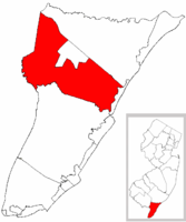
 Dennis Township highlighted in Cape May County. Inset map: Cape May County highlighted in the State of New Jersey. |
|
 Census Bureau map of Dennis Township, New Jersey |
|
| Coordinates: 39°12′23″N 74°49′06″W / 39.206513°N 74.818417°WCoordinates: 39°12′23″N 74°49′06″W / 39.206513°N 74.818417°W | |
| Country | |
| State |
|
| County | Cape May |
| Incorporated | March 1, 1827 |
| Government | |
| • Type | Township |
| • Body | Township Committee |
| • Mayor | John Murphy (D, term ends December 31, 2016) |
| • Clerk | Jacqueline Justice |
| Area | |
| • Total | 64.328 sq mi (166.611 km2) |
| • Land | 60.799 sq mi (157.470 km2) |
| • Water | 3.529 sq mi (9.141 km2) 5.49% |
| Area rank | 19th of 566 in state 3rd of 16 in county |
| Elevation | 16 ft (5 m) |
| Population (2010 Census) | |
| • Total | 6,467 |
| • Estimate (2015) | 6,315 |
| • Rank | 330th of 566 in state 5th of 16 in county |
| • Density | 106.4/sq mi (41.1/km2) |
| • Density rank | 540th of 566 in state 16th of 16 in county |
| Time zone | Eastern (EST) (UTC-5) |
| • Summer (DST) | Eastern (EDT) (UTC-4) |
| ZIP code | 08214 - Dennisville |
| Area code(s) | 609 exchanges: 624, 861 |
| FIPS code | 3400917560 |
| GNIS feature ID | 0882046 |
| Website | www |
Dennis Township is a township in Cape May County, New Jersey, United States. It is part of the Ocean City Metropolitan Statistical Area. The township's population as of the 2010 United States Census was 6,467, reflecting a decline of 25 (-0.4%) from the 6,492 counted in the 2000 Census, which had in turn increased by 918 (+16.5%) from the 5,574 counted in the 1990 Census.
Dennis Township was incorporated as a township by an act of the New Jersey Legislature on March 1, 1827, from portions of Upper Township. Portions of the township were taken to form Sea Isle City borough (May 22, 1882) and Woodbine borough (March 3, 1903).
New Jersey Monthly magazine ranked Dennis Township as its 20th best place to live in its 2008 rankings of the "Best Places To Live" in New Jersey.
According to the United States Census Bureau, the township had a total area of 64.328 square miles (166.611 km2), including 60.799 square miles (157.470 km2) of land and 3.529 square miles (9.141 km2) of water (5.49%).
Belleplain (2010 Census population of 597) is an unincorporated community and census-designated place (CDP) located within the township.
Dennisville is the most important unincorporated community in Dennis Township. Ocean View is served as ZIP code 08230. Other communities, localities and place names located partially or completely within the township include Clermont, East Creek, Eldora, Mount Pleasant, North Dennis, North-West Dennis, Ocean View, Savage Pond, South Dennis, South Seaville, Stipsons Island and West Creek Landing.
...
Wikipedia
