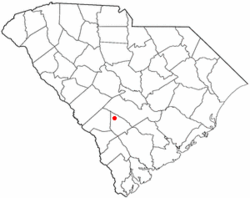
Denmark, South Carolina
| Denmark, South Carolina | |
|---|---|
| City | |
 Location of Denmark, South Carolina |
|
| Coordinates: 33°19′16″N 81°8′32″W / 33.32111°N 81.14222°WCoordinates: 33°19′16″N 81°8′32″W / 33.32111°N 81.14222°W | |
| Country | United States |
| State | South Carolina |
| County | Bamberg |
| Area | |
| • Total | 3.84 sq mi (9.94 km2) |
| • Land | 3.83 sq mi (9.93 km2) |
| • Water | 0.004 sq mi (0.01 km2) |
| Elevation | 240 ft (73 m) |
| Population (2010) | |
| • Total | 3,538 |
| • Density | 922/sq mi (356.1/km2) |
| Time zone | Eastern (EST) (UTC-5) |
| • Summer (DST) | EDT (UTC-4) |
| ZIP code | 29042 |
| Area code(s) | 803 |
| FIPS code | 45-19105 |
| GNIS feature ID | 1247519 |
Denmark is a city in Bamberg County, South Carolina, United States. The population was 3,538 at the 2010 census.
Denmark is located in northwest Bamberg County at 33°19′16″N 81°8′32″W / 33.32111°N 81.14222°W (33.321173, -81.142289).U.S. Route 78 and U.S. Route 321 cross in Denmark just north of the downtown area. US 78 leads east 6 miles (10 km) to Bamberg, the county seat, and west 8 miles (13 km) to Blackville. US 321 leads north 9 miles (14 km) to Norway and south 7 miles (11 km) to Govan.
According to the United States Census Bureau, the city has a total area of 3.8 square miles (9.9 km2), of which 0.004 square miles (0.01 km2), or 0.09%, is water.
As of the census of 2000, there were 3,328 people, 1,331 households, and 846 families residing in the city. The population density was 1,096.0 people per square mile (422.7/km²). There were 1,537 housing units at an average density of 506.2 per square mile (195.2/km²). The racial makeup of the city was 85.91% African American, 12.74% White, 0.09% Native American, 0.51% Asian, 0.06% from other races, and 0.69% from two or more races. Hispanic or Latino of any race were 0.75% of the population.
...
Wikipedia
