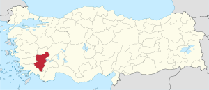
Denizli Province
|
Denizli Province Denizli ili |
|
|---|---|
| Province of Turkey | |
 Location of Denizli Province in Turkey |
|
| Country | Turkey |
| Region | Aegean |
| Subregion | Aydın |
| Government | |
| • Electoral district | Denizli |
| Area | |
| • Total | 12.321 km2 (4.757 sq mi) |
| Population (2010-12-31) | |
| • Total | 931,823 |
| • Density | 76,000/km2 (200,000/sq mi) |
| Area code(s) | 0258 |
| Vehicle registration | 20 |
Denizli Province (Turkish: Denizli ili) is a province of Turkey in Western Anatolia, on high ground above the Aegean coast. Neighbouring provinces are Uşak to the north, Burdur, Isparta, Afyon to the east, Aydın, Manisa to the west and Muğla to the south. It is located between the coordinates 28° 30’ and 29° 30’ E and 37° 12’ and 38° 12’ N. It covers an area of 11,868 km², and the population is 931,823. The population was 750,882 in 1990. The provincial capital is the city of Denizli.
Approximately 28-30% of the land is plain, 25% is high plateau and tableland, and 47% is mountainous. At 2571m Mount Honaz is the highest in the province, and indeed in Western Anatolia. Babadag in the Mentes range has a height of 2308 meters. The biggest lake in Denizli is Acıgöl, which means bitter lake and indeed industrial salts (sodium sulphate) are extracted from this lake which is highly alkaline. There is a thermal spring to the west of Sarayköy, at the source of the Great Menderes River, which contains bicarbonates and sulfates. There is another hot spring in Kizildere which reaches 200˚C.
A geothermal steam source was first found in the region in 1965 during drilling work. Today there is a power plant producing electricity from the geothermal steam. Only 11% of the geothermal energy source is used to produce electricity and 89% of it, which flows into the Great Menderes, is 150˚C at source (it is contains energy equal to 35,000 to 40,000 tonnes of fuel oil).
...
Wikipedia
