Delta, Ohio
| Delta, Ohio | |
|---|---|
| Village | |

|
|
 Location of Delta, Ohio |
|
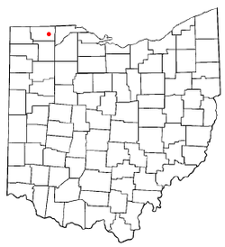
 Location of Delta in Fulton County |
|
| Coordinates: 41°34′30″N 84°0′9″W / 41.57500°N 84.00250°WCoordinates: 41°34′30″N 84°0′9″W / 41.57500°N 84.00250°W | |
| Country | United States |
| State | Ohio |
| County | Fulton |
| Government | |
| • Type | Charter Municipality |
| • Mayor | Dan D. Miller |
| Area | |
| • Total | 2.67 sq mi (6.92 km2) |
| • Land | 2.67 sq mi (6.92 km2) |
| • Water | 0 sq mi (0 km2) |
| Elevation | 722 ft (220 m) |
| Population (2010) | |
| • Total | 3,103 |
| • Estimate (2012) | 3,083 |
| • Density | 1,162.2/sq mi (448.7/km2) |
| Time zone | Eastern (EST) (UTC-5) |
| • Summer (DST) | EDT (UTC-4) |
| ZIP code | 43515 |
| Area code(s) | 419 |
| FIPS code | 39-21616 |
| GNIS feature ID | 1079943 |
| Website | http://www.villageofdelta.org |
Delta is a village in Fulton County, Ohio, United States. The population was 3,103 at the 2010 census.
The first settlement at Delta was made in the 1830s. A post office called Delta has been in operation since 1837. The village was incorporated about 1863.
Delta is located at 41°34′30″N 84°0′9″W / 41.57500°N 84.00250°W (41.575090, -84.002477).
According to the United States Census Bureau, the village has a total area of 2.67 square miles (6.92 km2), all land. Delta lies within the watershed of the Maumee River. Bad Creek, a tributary of the Maumee River, flows through the village. Alternate U.S. 20 and State Route 2 pass through the village in an east-west direction. State Route 109 goes through the village in a north-south direction. The Ohio Turnpike runs in an east-west direction approximately two miles north of the village. There is an interchange at the intersection of State Route 109 and the Ohio Turnpike.
As of the census of 2010, there were 3,103 people, 1,203 households, and 842 families residing in the village. The population density was 1,162.2 inhabitants per square mile (448.7/km2). There were 1,293 housing units at an average density of 484.3 per square mile (187.0/km2). The racial makeup of the village was 96.1% White, 0.4% African American, 0.5% Native American, 0.5% Asian, 0.9% from other races, and 1.6% from two or more races. Hispanic or Latino of any race were 5.3% of the population.
...
Wikipedia
