Delphos, Kansas
| Delphos, Kansas | |
|---|---|
| City | |
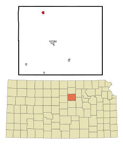
 Location within Ottawa County and Kansas |
|
 KDOT map of Ottawa County (legend) |
|
| Coordinates: 39°16′29″N 97°45′59″W / 39.27472°N 97.76639°WCoordinates: 39°16′29″N 97°45′59″W / 39.27472°N 97.76639°W | |
| Country | United States |
| State | Kansas |
| County | Ottawa |
| Area | |
| • Total | 0.64 sq mi (1.66 km2) |
| • Land | 0.62 sq mi (1.61 km2) |
| • Water | 0.02 sq mi (0.05 km2) |
| Elevation | 1,299 ft (396 m) |
| Population (2010) | |
| • Total | 359 |
| • Estimate (2015) | 345 |
| • Density | 560/sq mi (220/km2) |
| Time zone | CST (UTC-6) |
| • Summer (DST) | CDT (UTC-5) |
| ZIP code | 67436 |
| Area code | 785 |
| FIPS code | 20-17600 |
| GNIS feature ID | 0476142 |
Delphos is a city in Ottawa County, Kansas, United States. As of the 2010 census, the city population was 359. The community was named after Delphos, Ohio.
Delphos was founded in 1867 by Levi and Dan Yockey. The two brothers moved to the area from Delphos, Ohio and named the new community for their hometown. Many settlers came to the area looking for a fresh start after the Civil War.
Delphos is located at 39°16′29″N 97°45′59″W / 39.27472°N 97.76639°W (39.274770, -97.766377). According to the United States Census Bureau, the city has a total area of 0.64 square miles (1.66 km2), of which, 0.62 square miles (1.61 km2) is land and 0.02 square miles (0.05 km2) is water.
The city is located on the Solomon River and is six miles west of U.S. Route 81.
Delphos is part of the Salina Micropolitan Statistical Area.
As of the census of 2010, there were 359 people, 161 households, and 104 families residing in the city. The population density was 579.0 inhabitants per square mile (223.6/km2). There were 222 housing units at an average density of 358.1 per square mile (138.3/km2). The racial makeup of the city was 96.4% White, 0.8% African American, 0.3% Native American, 0.8% from other races, and 1.7% from two or more races. Hispanic or Latino of any race were 2.2% of the population.
...
Wikipedia
