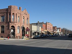
Dell Rapids, South Dakota
| Dell Rapids, South Dakota | |
|---|---|
| City | |
 |
|
 Location in Minnehaha County and the state of South Dakota |
|
| Coordinates: 43°49′30″N 96°42′40″W / 43.82500°N 96.71111°WCoordinates: 43°49′30″N 96°42′40″W / 43.82500°N 96.71111°W | |
| Country | United States |
| State | South Dakota |
| County | Minnehaha |
| Founded | 1871 |
| Incorporated | 1888 |
| Area | |
| • Total | 2.09 sq mi (5.41 km2) |
| • Land | 2.03 sq mi (5.26 km2) |
| • Water | 0.06 sq mi (0.16 km2) |
| Elevation | 1,509 ft (460 m) |
| Population (2010) | |
| • Total | 3,633 |
| • Estimate (2015) | 3,706 |
| • Density | 1,789.7/sq mi (691.0/km2) |
| Time zone | Central (CST) (UTC-6) |
| • Summer (DST) | CDT (UTC-5) |
| ZIP code | 57022 |
| Area code(s) | 605 |
| FIPS code | 46-15980 |
| GNIS feature ID | 1265635 |
| Website | City of Dell Rapids |
Dell Rapids is a city in Minnehaha County, South Dakota, United States. The population was 3,633 at the 2010 census. It is known as "The little city with the big attractions."
The city took its name from the Dells of the Wisconsin River, which were likened to the local rapids on the Big Sioux River.
Dell Rapids is located at 43°49′30″N 96°42′40″W / 43.82500°N 96.71111°W (43.824883, -96.711158), along the Big Sioux River.
According to the United States Census Bureau, the city has a total area of 2.09 square miles (5.41 km2), of which, 2.03 square miles (5.26 km2) is land and 0.06 square miles (0.16 km2) is water.
Dell Rapids has been assigned the ZIP code 57022 and the FIPS place code 15980.
As of the census of 2010, there were 3,633 people, 1,388 households, and 973 families residing in the city. The population density was 1,789.7 inhabitants per square mile (691.0/km2). There were 1,495 housing units at an average density of 736.5 per square mile (284.4/km2). The racial makeup of the city was 98.0% White, 0.1% African American, 0.6% Native American, 0.2% Asian, 0.2% from other races, and 0.9% from two or more races. Hispanic or Latino of any race were 1.4% of the population.
...
Wikipedia
