Deir Hanna
Deir Hanna
|
|
|---|---|
| Hebrew transcription(s) | |
| • ISO 259 | Deir Ḥannaˀ |
| • Also spelled | Deir Hana (official) Dayr Hanna (unofficial) |

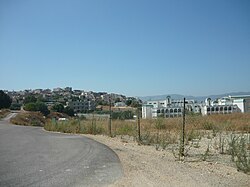
An entry into Deir Hanna, 2010
|
|
| Coordinates: 32°51′44.68″N 35°22′16.21″E / 32.8624111°N 35.3711694°ECoordinates: 32°51′44.68″N 35°22′16.21″E / 32.8624111°N 35.3711694°E | |
| Grid position | 184/252 PAL |
| District | Northern |
| Government | |
| • Type | Local council (from 1975) |
| • Head of Municipality | Samir Hussein |
| Area | |
| • Total | 7,500 dunams (7.5 km2 or 2.9 sq mi) |
| Population (2015) | |
| • Total | 9,831 |
| Name meaning | Convent of St John |
Deir Hanna (Arabic: دير حنا, Hebrew: דֵיר חַנָּא) is a local council in the Northern District of Israel, located on the hills of the Lower Galilee, 23 kilometres (14 mi) southeast of Acre. In 2015 it had a population of 9,831. Approximately 80% of Deir Hanna's inhabitants are Muslims and the remaining 20% are Christians.
Several etymologies had been presented including:
In the Crusader era, Deir Hanna was a fief known as Berhenne, or Der Henne. In 1174 it was one of the casales (villages) given to Phillipe le Rous. In 1236 descendants of Phillipe le Rous confirmed the sale of the fief of Deir Henna. According to architectural researcher Andrew Petersen, no traces of Crusader occupation were found in the village.
Deir Hanna became a base for the Zaydānī family in the 18th century, and thus its importance grew with Zahir al-Umar's rise to power during that time. In the early to mid-18th century, Zahir gave his elder brother, Sa'd el-Omar, control of the village and nearby Arraba. The two villages served as the rural stronghold of the Zaydani family, and before taking the port town of Acre, Zahir resided in Deir Hanna and used it as his principal base of operations. Sa'd commissioned the construction of most of Deir Hanna's fortifications and in 1732-33, he built its mosque. When Sa'd died in 1767, Zahir's son Ali requested control over the village, but Zahir refused, earning him Ali's resentment.
...
Wikipedia

